Anatolia :facts and not fiction at all(4)– Anatolia or Anarta of Sharyati in Gujarat ? Anarta= lost continent Atlantis

Matsya or Mitanni Kingdom of Anatolia?

We have checked history of ancient Anatolia.. We found Haihaya,Pala, Zala , Lau , Kush , Hastinga presence there. Surprising Matsya presence was also there.Surprisingly , Hurrian kingdom Mitanni is clue to Matsya kingdom of India and present day Hungary. Mitanni kingdom ,its Gods and capital “Washukanni “ connects the kingdom with ancient Matsya kingdom of Bharatvarsha.

Mitanni people were worshipers of Sun ,Indra and Varuna. Present Kurdish people are clue to ancient Anatolia. Washukanni was capital of Mitanni. If we look at facts about Matsya kingdom of India then Uparichara Vasu was first king of Matsya kingdom of India before Mahabharat war faught. Now let us check historical facts about their migration story.

Mitanni kingdom of Anatolia

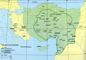
Mitanni or Hanigalbat (Hanigalbat, Khanigalbat ) was a loosely organized Hurrian -speaking state in northern Syria and south-east Anatolia from ca. 1500 BC -1300 BC. Founded by an Indo-Aryan ruling class governing a predominately Hurrian population, Mitanni came to be a regional power after the Hittite destruction of Amorite Babylon created a power vacum in Mesopotamia. At the beginning of its history, Mitanni’s major rival was Egypt under the Thutmosids. However, with the ascent of the Hittite empire, Mitanni and Egypt made an alliance to protect their mutual interests from the threat of Hittite domination. At the height of its power, during the 14th century BC, it had outposts centered around its capital, Washukanni, whose location has been determined by archaeologists to be on the headwaters of the Khabur River. Eventually, Mitanni succumbed to Hittite and later Assyrian attacks, and was reduced to the status of a province of the Middle Assyrian Empire.
Their sphere of influence is shown in Hurrian place names, personal names and the spread through Syria of a distinct pottery type.
The ethnicity of the people of Mitanni is difficult to ascertain. A treatise on the training of chariot horses contains a number of Indo-Aryan glosses. Kammenhuber (1968) suggested that this vocabulary was derived from the still undivided Indo -Iranian language, but Mayrhofer (1974) has shown that specifically Indo-Aryan features are present.
The names of the Mitanni aristocracy frequently are of Indo-Aryan origin, but it is specifically their deities which show Indo –Aryan roots (Mitra, Varuna, Indra, Nasatya), though some think that they are probably more immediately related to the Kassites. The common people’s language, the Hurrian languge is neither Indo -Eueropean nor Semitic. Hurrian, and thus the Hurrians, are therefore believed to be relatives of Urartu, both belonging to the Hurro –Uratian language family. indicates that the royal family of Mitanni was by then speaking Hurrian as well.
King Barattarna of Mitanni expanded the kingdom west to Halab (Aleppo) and made Idrimi of Alalakh his vassal. The state of Kizzuwatna in the west also shifted its allegiance to Mitanni and Arrapha and Assyria in the east had become Mitannian vassal states by the mid 15th century BC. The nation grew stronger during the reign of Shaushtatar but the Hurrians were keen to keep the Hittites inside the Anatolian highland. Kizzuwatna in the west and Ishuva in the north were important allies against the hostile Hittites.
Link to Mitani kindom.

Link -2 for more facts.

Capital Washukanni

Washukanni was the capital of the Hurrian kingdom of Mitanni, from c. 1500 BC to the 13th century BC. Its precise location is unknown, but it is widely thought to have existed on one of the tributaries of the Khabur River. Some scholars believe it is identical with the later, ancient city of Sikan. Washukanni may be located under the so-far unexcavated mound of Tell el Fakhariya, near Gozan in Syria, to the east of the Euphrates river.

Washukanni means beautiful source/springhead. The kurdish town Sikan (which scholars believe, its Wassukani) is named as Serêkanî or Serêkaniyê in Kurdish and it means Headwater.
The city is known to have been sacked by the Hittites under Suppiluliumas (reigned c.1344–1322 BC) in the first years of his reign, whose treaty inscription relates that he installed a Hurrian vassal king, Shattiwaza. The city was sacked again by the Assyrian king Adad Nivari I around 1290 BC, but very little else is known of its history.

For further facts refer following Book Link “Études mithriaques”
edited by Jacques Duchesne-Guillemin, Congrès International d&Etud
Book link
Now let us look facts about ancient Matsya Janpad of Bharatvarsha.

Matsya Janpad of India

Matsya or Machcha (Sanskrit for fish), classically called the Mese, was the name of a tribe and the state of the Vedic civilization of India. It lay to south of the kingdom of Kurus and west of the Yamuna which separated it from the kingdom of Panchalas. It roughly corresponded to former state of Jaipur in Rajasthan, and included the whole of Alwar with portions of Bharatpur. The capital of Matsya was at Viratanagara (modern Bairat) which is said to have been named after its founder king Virata. In Pali literature, the Matsya tribe is usually associated with the Sursena. The western Matsya was the hill tract on the north bank of Chambal. Meenas are considered the brothers and kinsmen of Virata, the ruler of Virat Nagar. They ruled this area (near to Virat Nagar) till 11th century CE.
Matsya Kingdom was founded by fishermen community who later attained kingship. The Sanskrit word Matsya means fish. Satyavati, the wife of Kuru king Santanu was from this community. King Verata, a Matsya king, founded the kingdom of Viarata. He was the father-in-law of Abhimanyu, the son of Arjuna. The epic Mahabharata relates the founder of Matsya kingdom to the ruler of Chedi, viz Uparichara Vasu.

Fishing was the main occupation of the people who lived near river Sarswati River. After the river dried up, they migrated to river Charmanwati now known as Chambal meaning fish in Dravidan language. Krishna Dwajpayana Vyasa, was son of Satyavati who belonged to this fishermen community and yet was a Vedic scholar.
Other than the Matsya kingdom to the south of Kuru Kingdom, which falls in the Alwar ,Bharatpur districts of Rajasthan, the epic refers to many other (as many as, six other) Matsya kingdoms. The main Matsyas under Virata had its capital named Viratnagri which is now known as Bairat in Jaipur district of Rajasthan. Upaplvya was another famous city in this kingdom.
In the ancient times Rajasthan was ruled by a dynasty of Meenas which had the emblem of Fish like the Pandyan Kingdom (Paravar, Karava, Kariyar) of the south. The name Mina is derived from Meen and the Minas descent from the Matsya Avatar (Meena Avatar)of God. Matsya Avatar (Mina Avatar) takes place to save the pious and the first man, Manu.
The first Matsya king was mentioned to be the son of a Chedi king named Uparichara Vasu. He was a Paurava, meaning a king beloning to the Puru dynasty (1,63). Apart from the five royal sons of this king, he had a son and a daughter born of a women of fisherman community. The male child, in due cource established the Matsya Kingdom and founded the royal dynasty called Matsya Dynasti. The female child lived as a member of fishermen community. Her descendants established as fishermen on the banks of river Yamuna, in the kingdom of Kurus. The famous Kuru king Santnu’s wife Satyawati was from this fishermen community. The author of Mahabharata, vis Krishna Dwajpayana Vyasa and the Kuru kings viz Chitrangada and Vichitravirya were the sons of Satyavati. Pandavas and Kauravas where the grandsons of Vichitravirya.(1,63).

The most famous Matsya kingdom was the one under the rule of king Virata, the ally of the Pandavas. Most of the other Matsyas joined with the Kauravas in Kurukshetra War. Sahdeva on his military campaign to the south, to collect tribute for Yudhisthira’s Rajasuya sacrifice, encountered this Matysas. He also encountered the Matsya kingdom that lay to the south of Matsya-proper (Virata Kingdom).
On the side of Pandava

Pandavas selected the Virata Kingdom to be their abode for one year, to live in anonymity, after the expiry of their twelve-year long forest life, both (12-years of forest life and one year of life in anonymity) being the conditions set up by their enemies viz the Kaurava, to give them back their kingdom (4,1). They become ally of Pandava.

On the side of Kauravas

Some Matsya tribes (possibly all except the Virata Kingdom and the Southern Matsyas) allied with the Kauravas (5-161,162). At (6,18) they were described as one among the 12 tribes (The Abhishahas, the Surasenas, the Sivis, and the Vasatis, the Salweyas, the Matsyas, the Amvashtas, the Trigartas, and the Kekayas, the Sauviras, the Kitavas and another tribe) that protected the Kaurava commander-in-chief Bhishma. At (8,56) they were mentioned along with the Bahlikas, and the Kaikayas, the Vasatas, the Madras, and Saindhavas.

Link

Uparichara Vasu
Uparichara Vasu was a king in the race of Puru. He invaded the Chedi kingdom and later became famous as the king of Chedi. He had two wives named Girika and Adrika both belonging to two different non-Vedic tribes. Girika was a mountain dweller, where as Adrika was a fisher-women.

Satyavati : Daughter of Vasu

Satyavati (also spelled Satyawati) was the queen of the Kuru king Shantanu of Hastinapur and the great-grandmother of the Pandava and Kaurava princes (principal characters of the Mahabharta, one of the principal texts in Hindu Mythology). She is also the mother of the seer Vyasa, author of the epic. Her story appears in the Mahabharata, the Harivamsa and the Devi Bhagavata Purana.
Daughter of the chedi king Vasu (also known as Uparichara Vasu) and a cursed Apsara (celestial nymph)-turned-fish Adrika, Satyavati was brought up as a commoner – the adopted daughter of a fisherman-chieftain (who was also a ferryman, Paravas) on the banks of the river Yamuna. Due to the smell emanating from her body she was known as Matsyagandha (“She who has the smell of fish”), and helped her father in his job as a ferryman.
As a young woman Satyavati met the wandering Rishi (sage) Parashara, who fathered her son Vyasa out of wedlock. The sage also gave her a musky fragrance, which earned her names like Yojanagandha (“She whose fragrance is spread for a Yojana (8-9 miles)”) and Gandhavati (“fragrant one”).
Later King Shantanu, captivated by her fragrance and beauty, fell in love with Satyavati and asked her to marry him. She married Santanu on condition that their children inherit the throne, denying the birthright of Santanu’s eldest son (and crown prince) Bhishma. Satyavati bore Shantanu two children, Chitrangada and Vichitravirya. After Shantanu’s death, she and her princely sons ruled the kingdom. Although both her sons died childless, she arranged for her first son Vyasa to father the children of the two widows of Vichitravirya through Niyoga.

Link to Satyavati

Migration story of Matsya

Now let us look at migration story of Matsya.
Now we know that Mitanni or Hanigalbat (Hanigalbat, Khanigalbat cuneiform ) was a loosely organized Hurrian -speaking state in northern Syria and south-east Anatolia from ca. 1500 BC -1300 BC.

Hurrian /Hungarian/ kingdom of Khwarezmia

The Hungarian nation throughout it’s known history has at least three distinct names, not counting the other six tribal names which are also traceable back into antiquity. ( the other tribal names are Kari, Kasi, Kurt-Gyarmat, Tarjan/Tarxan, Jenu, Nyek) These three names whose roots are to be discussed refered more to the leading nation, which also could have had its unique independent origin. Starting with the oldest references and advancing to the newest are the following at different times and different language
Another name of this area, or perhaps more specificly one of the kingdoms of the Subarian people was known as “Hurri, Gurri”. The Hurri language is generally the accepted term today for the language of the people of Subar-Tu. Their language was also agglutinative like Sumerian and had many words in common, yet it was a distinct language from it. Hungarian also has some words in common with both Sumerian, Hurrian and Elamite.Elamite is considered a sister tongue of Dravidian who are now constricted to southern India, but were once living in the north. It is no accident that Hungarian also shares many words also with Dravidian and Turkic languages also. All of this indicates that they were at one time less isolated from one another.
The Hurrian descendants also founded the kingdom of Urartu as well as the central Asian kingdom of Khwarezmia,( Indian word Kharwa for fisherman is outcome of that kingdom?) next to the Aral Sea.( S.P.Tolstov, Ancient Khwarezmia, Moscow, 1947 ) [Some Russian researchers claim that Khwarezmia and its area was the possible origin of the Finno-Ugrian and Altaic nations!] The people of Subartu (Hurrians and Subars) lived predominantly in northern Mesopotamia but in very ancient times also in southern Mesopotamia.
Link will say facts in Detail

Hungary / Magyars / the Manicha-Er group

Hungary is a landlocked country in central Europe. It is situated in the Carpethian Basin and is bordered by Slovakia to the north, Ukraine and Romania to the east, Serbia and Croatia to the south, Slovenia to the southwest and Austria to the west. The capital and largest city is Budapest. Hungary is a member of the European Union,NATO. The official language is Hungarian, also known as Magyar, which is part of the Finno – Ugric group and is the most widely spoken non-Indo -European language in Europe.
The freshly unified Magyars (Hungarians) led by Arpad settled in the Carpethian Basin starting in 895. According to linguists, they originated from an ancient Uralic -speaking population that formerly inhabited the forested area between the Volga river and the Ural mountains.
.
The Magyar tribes/”Meshchera”

The Magyar tribes were the fundamental political units whose framework the Hungarians (Magyars) lived within, until these Clans from Asia, more accurately from the region of Ural Mountains, invaded the Carpathian Basin and established the Principality of Hungary.
The locality in which the Hungarians, the Manicha-Er group, emerged was between the Volga river and the Ural Mountains. Between the 8th and 5th centuries BC, the Magyars embarked upon their independent existence and the early period of the proto Magyar language began. Some say the name “Meshchera” relates to the Hungarians’ self-name “magyar”.

Link

Budapest or Bairat?
The name “Budapest” is the composition of the city names “Buda” and “Pest”, since they were united (together with Obuda) to become a single city in 1873. One of the first occurrences of the combined name “Buda-Pest” was in 1831 in the book “Világ” (“World” / “Light”), written by Count Istvan Szechenyi.

The origins of the words “Buda” and “Pest” are obscure. According to chronicles from the Middle Ages, the name “Buda” comes from the name of its founder, Bleda (Buda), the brother of the Hunnic ruler Attila. The theory that “Buda” was named after a person is also supported by modern scholars. An alternative explanation suggests that “Buda” derives from the Slavic word ” voda” (“water”), a translation of the Latin name ” Aquincum”, which was the main Roman settlement in the region.

Yes Vilag is mysterious word and give clue to Virat ,founded by Matsya Viratraj , who fought for Pandava.
Book link to “Vilag “

Now we know that Hungary stands for Magyar tribe and its root word is “Meshchera”.Let us dig further for “The Meshchera tribe”.

The Meshchera

The Meshchera language was a Uralic spoken by the Meshchera tribe, in what is today the Oka River basin in Russia. Very little is known about the language, but it was probably closely related to the Mordvinic languages Moksha and Erzya. Meshchera language probably became extinct by the 16th century.

Link for more facts
Following link says that “The world is changing! A thousand years ago the political and ethnical map was very different. The forest plains of the North-East of Europe, from the Urals to the Lapland was populated by the Finno-Ugrian peoples, the ancestors of modern Finns, Hungarians, Estonians, Mordvins, Mari, Udmurts and many others, including those living in the Russian North and Western Siberia.”
Second link

Further Following link about MESHCHERA also give clue to Finnish tribes: Merya and Murom .The link says that ……

MESHCHERA

Most people associate the word meshchera with the territory of forests, pit bogs and lakes between the Klyazma and Oka rivers called Meshchera lowlands. This name originates from a medieval tribe of Volga-Finns, the Meshchera.
Written records
The first Russian document mentioning the Meshchera is Tolkovaya Paleya (13c. AD). The tribe was also often mentioned in Russian chronicles and other documents before the 16th century.
The Will of the Moscow prince Ivan Ivanovich (1358) mentions the village of Meshcherka which, as we can learn from another document, had been purchased from the indigenous Meshcherian prince Alexander Ukovich. There are some indications that this western Meshcherian dynasty had been converted to Orthodoxy and was a vassal of the Moscow princes.
Generally speaking, we can easily find the Meshchera in Russian documents of the 13th-16th centuries, unlike the other Finnish tribes: Merya and Murom which had been assimilated by Slavs before the 10th-11th centuries AD. A number of the documents mentions the Meshchera in connection with the Kazan campaign of Ivan the Terrible (16th c.). Some of those mentions relate to the Temnikov Meshchera, a state where the indigenous Meshchera of that time had lost their national identity in many ways by being assimilated by the Tatars and Mordvins. There is a written confirmation of this by Prince A.M. Kurbsky, which referred to the spoken Mordvin language in the Meshchera land.

Link for More facts

Following link also give clues to Meshchera tribe…

The Lost World of Meshchera

“The world is changing! A thousand years ago the political and ethnical map was very different. The forest plains of the North-East of Europe, from the Urals to the Lapland was populated by the Finno-Ugrian peoples, the ancestors of modern Finns, Hungarians, Estonians, Mordvins, Mari, Udmurts and many others, including those living in the Russian North and Western Siberia.
Not all Finno-Ugrian nations survived. One of those extinct was Meshchera. The name of this nation apparently originates from the word “machjar” which was a self-name in the Middle Ages. The Meshcha descendants kept their own phonetics for a long time, preserving hard “ch” – strange for a Russian ear [18].
The spelling and pronunciation of “Machjar” (maybe “Mezhchar”]) have been transformed in accordance with the norms of the Old Russian language. These changes made the new word “Meshchera” to sound very Russian, like the Old-Russian words “veshchy”, “meshchati”, “meshchenye”, “peshchera” and now create an illusion of its “russianness” including relation to the Russian word “mshara” (a pit bog). We also doubt with transformation to “Meshchera” the Mordvin word “meshkyar” (a bee keeper)
It is much more difficult to find the origin of the primary word. Some say is relates to the Mari word “mezh” (wool) the others – to the Baltic “mezh” (forest)]. But why the Balts, living in the same virgin forests called the Meshchera “the forest people”? Some say the name “Meshchera” relates to the Hungarians’ self-name “magyar” But the chronicles say the Meshchera had own language . which is now, alas, extinct.”

Link

Merya / Muromian / Meshchera

The Volga Finns (sometimes referred to as Eastern Finns) are a historical group of Indigenous people of Russia whose descendants include the Mari people, the Erzya and the Moksha Mordyins, as well as extinct Merya, Muromian and Meshchera people.The Permians are sometimes also grouped as Volga Finns.
The modern representatives of Volga Finns live in the basins of the Sura and Moksha Rivers, as well as (in smaller numbers) in the interfluve between the Volga and the Belaya Rivers. The Mari language has two dialects, the Meadow Mari and the Hill Mari.
Traditionally the Mari and the Mordvinic languages ( Erzya and Moksha) were forming a Volga–Finnic or Volgaic group within the Finno -permic branch of the Uralic language family, suggested by linguists like Robert Austerlitz. (1968), Aurélien Sauvageot & Karl Heinrich Menges (1973), Harald Harrmann (1974) and Charles Frederick Voegelin & Florence Marie Voegelin (1977), and rejected by others like Bjorn Collinder (1965) and Robert Thomas Harms (1974).

The Mari or Cheremis ( You read about Meenas. They were dwelling at Charmavati or Chambal river) have traditionally lived along the Volga and Kama rivers in Russia. The majority of Maris today live in the Mari EI Republic, with significant populations in the Tatarstan and Bashkortostan republics.

The Merya people (also Merä) inhabited a territory corresponding roughly to what is now the area of the Golden Ring or Zalesye region of Russia including the modern-day Moskow, Yaroslavl ,kastroma,Ivanova, and Vladimir oblasts.
They were briefly mentioned in the 6th century by Jordens (as Merens) and were later described in more detail by the Primary chronicle. Soviet archaeologists believed that the capital of the Merya was Sarskoe Gorodishche on the bank of the Nero lake to the south of Rostov. They are thought to have been peacefully assimilated by the East slavs after their territory became incorporated in the Kievan Rus in the 11th century.

Moscow / Meshchera /Matsya

The Meshchera lived in the territory between the Oka river and the Klyazma river. It was a land of forests, Bogs and lakes. The area is still called the Meshchera lowlands.
This is in stark contrast to the related tribes Merya and Muroma, which appear to have been assimilated by the East Slavs by the 10th and the 11th centuries. Ivan II, prince of Moscow, wrote in his will, 1358, about the village Meshcherka, which he had bought from the native Meshcherian chieftain Alexander Ukovich. The village appears to have been converted to the Christian Orthodox faith and to have been a vassal of Muscow.
The Meschiera (along with Mordua ,sibir and a few other harder-to-interpret groups) are mentioned in the “Province of Russia” on the Venetian Fra Mauro Map (ca. 1450)
Link for further facts.
We know that when Pandava in Guptvasa stayed in Matsya Virat kingdom. Surprisingly There is town called Virrat In Pirkanmaa region of finland. There is Satkunta – Maakunta province too there. in funland.Is it merely co –incidence? Aisa Bhi Hota hai?

Khwarezm

Khwarezm, or Chorasmia, is a large Oasis region on the Amy Darya river in western Central Asia, which borders to the north the (former) Aral sea, to the east the Kyzylkum desert, to the south the Karakum desert and to the west the Ustyurt plateau. It was the center of the (indigenous) Khwarezmian civilization and a series of kingdoms, whose capitals were (among others) kath, Gurangi (the modern Loneurgenc) and, from the 16th century on, Khiva. Today Khwarezm belongs partly to Uzbekistan and partly to Turkmenistan.

The Arab geographer Yagut al –Hamawi wrote that the name was a compound (in Persian) of khwar and razm , referring to the abundance of cooked fish as a main diet of the peoples of this area.

C.E.Bosworth however, believes the Persian name to be made up of meaning “the sun” and meaning “Earth”, designating “the land from which the sun rises”.Another view is that the Iranic compound stands for “lowland” from kh(w)ar “low” and zam “earth, land.”. Khwarezm is indeed the lowest region in Central Asia (except for the Caspian Sea to the far west), located on the delta of the Amu Darya on the southern shores of the Aral sea. Various forms of khwar/khar/khor/hor are commonly used also in the Persian Gulf to stand for tidal flats, marshland, or tidal bays (e.g., Khor Musa,Khor Abdallah, Hor al – Azami,Hor al Himar, etc.)
The name also appears in Achaemenid inscriptions as Huvarazmish, which is declared to be part of the Persian Empire.

Some of the early scholars believed Khwarezm to be what ancient Avestic texts refer to as Airyanem Vaejah (“Ariyaneh Waeje”; later Middle Persian Iran vij). These sources claim that Old Urgench, which was the capital of ancient Khwarezm for many years, was actually Ourva, the eighth land of Ahura Mazda mentioned in the Pahalavi text of Vendidad. However, Michael Witzel, a researcher in early Indo-European history, believes that “Airyanem Vaejah” was located in what is now Afghanistan, the northern areas of which were a part of ancient Khwarezm and Greater Khorasan. Others, however, disagree. University of Hawai historian Elton L Daniel believes Khwarezm to be the “most likely locale” corresponding to the original home of the Avestan people , and Denkhoda calls Khwarezm (“the cradle of the Aryan tribe”).

………
Virrat in Finland

Virrat is a town and municipality of Finland.
It is part of the Pirkanmaa region. The town has a population of 7,498 (31 January 2011) and covers an area of 1,299.07 square kilometres (501.57 sq mi)
The municipality is unilingually Finnish. Virrat crater on Mars is named after it.
Major lakes in the area are Toisvesi, by which the town of Virrat is located, and Tarjanne at the border of the municipalities of Virrat, Mantta –Vippula and Rouvesi .There is Sat Kunta – Maakunta procvince there too in Finland. Means Pandava again stayed in Matsyadesh in Guptvas (Hiding period)? Is it not Sanatan? Aisa Bhi Hota Hai?

Satakunta

Satakunta (Swedish: Satakunda, Latin: Finnia Septentrionalis or Satagundia) is a region (maakunta / landskap) of Finland, part of the former Western finland Province. It borders the regions of Finland proper,Pirkanmaa, Southern Ostrobothinia and Ostrobothnia. The main city of the region is Pori. The name of the region literally means Hundred. The historical province of same name was a larger area within Finland, covering modern Satakunta as well as much of Pirkanmaa…..

Link to Satakunta

Link to similar Ideology

Link for further facts

Link for Kurdistan
————————————————

At the end of the reasrech

Matsyaraja – son of Hanuman

Hanuman became more important in the medieval period, and came to be portrayed as the ideal devotee (Bhakt) of Rama. His characterization as a lifelong Brahmchari (celibate) was another important development during this period. The myth that Hanuman’s celibacy is the source of his strength became popular among the wrestlers in India. The celibacy or brahmacharya aspect of Hanuman is not mentioned in the original Ramayana. The original Valmiki Ramayana mentions that Bharata presented Hanuman with 16 maidens as a reward. The non-Indian versions of Ramayana, such as the Thai Ramakein, mention that Hanuman had relationships with multiple women, including Svayamprabha, Benjakaya (Vibhisana’s daughter), Suvannamaccha Suvannamaccha and even Ravana’s wife Mandodari. According to these versions of the Ramayana , Macchanu is son of Hanuman borne by Suvannamaccha, daughter of Ravana. The Jain text Paumacariya also mentions that Hanuman married Lankasundari, the daughter of Lanka’s chief defender Bajramukha.
Matsyaraj / Makardhwaj /River Machchu of Saurashtra ?
Another legend says that a demigod named Matsyaraja (also known as Makardhwaja or Matsyagarbha) claimed to be his son. Matsyaraja’s birth is explained as follows: a fish (matsya) was impregnated by the drops of Hanuman’s sweat, while he was bathing in the ocean.

Link to Hanumanji and His son

Meshchera people

The Volga Finns (sometimes referred to as Eastern Finns) are a historical group of indigenous peoples of Russia whose descendants include the Mari people, the Erzya and the Moksha Mordvins, as well as extinct Merya, Muromian and Meshchera people. The Permians are sometimes also grouped as Volga Finns.
The modern representatives of Volga Finns live in the basins of the Sura and Moksha River, as well as (in smaller numbers) in the interfluve between the Volga and the Belaya Rivers. The Mari Language has two dialects, the Meadow Mari and the Hill Mari.
Link to Meshchera people people

————————————
At the end of research

Anarta / Anatolia / Atlantis

We have found lost continent Atlantis

At the end of research we find that Anatolia was carrying history of ancient Anarta kingdom of Bharatvarsha. That Shryati founded in present day Gujarat. capital city of Anarta was Kushasttali. Kushsthali was beneath ocean. ya Anarta = lost continent of Atlantis. Now we find that original root word of Crete was Kursawar or Kussattar. .Shryati happened to be prior to Ram and river Saryu was named after Sharyati. Pl read The detail I mention in the chapter 7(1).

lINK TO ARCHAEOLOGICAL RESEARCH OF KUSHSTHALI .CAPITAL BENEATH OCEAN

lINK TO THE BOOK OF HELENE PETROVNA BLAVATSKY ( BLIEVE ME HELENE HAS =NOT SOMETHING BUT EVRYTHING – TO DO WITH KRISHA AND PURTICULARLY WITH BALDEV AND ..HALAR..ANARTA) READ PAGE -239

Now if we find all these indian Royals in Anatolia..then it is not matter of Surprise.they were carrying their traditions only.

PL READ DETAILS IN CHAPTER – 7(1)of Book section

Posted in Aisa bhi hota hai | Leave a comment

chapter-7 : Lau and Kush vanshis in Anatolia – or Anarta of Sharyati in Gujarat ?(2) Anarta = lost continent Atlantis

And now Lauvanshis in Anatolia

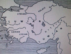
Luvians
People of southwest Anatolia in the 2nd millennium BC, who spoke an Indo-European language that was related to Hittite and Lydian. The Luvians may have contributed to the collapse of the Hittite empire.

Luwians in Anatolia

Luwians followed Hittite people in Anatolia. Presense of Pala, Zala ,Pandyan and Haihaya says that Luwians were Indian Entity.


The latest hieroglyphic Luvian inscriptions date from the 7th century BC, and Lycian (written from about 600 to 200 BC) is believed to derive from a Luvian dialect.
Link-1

Link -2

Luwian Language

Luwian (sometimes spelled Luvian) is an extinct language of the Anatolian branch of the Indo-European language family. Luwian is closely related to Hittite, and was among the languages spoken by population groups in Arzawa, to the west or southwest of the core Hittite area. In the oldest texts, eg. the Hittite Code, the Luwian-speaking areas including Arzawa and Kizzuwatna were called Luwia. In the post-Hittite era, the region of Arzawa came to be known as Lydia (Assyrian Luddu, Greek ).

Luwian is either the direct ancestor of Lycian, or a close relative of the ancestor of Lycia. Luwian is also one of the likely candidates for the language spoken by the Trojans, alongside a possible Tyrrhenian language related to Lemnian.

From this homeland, Luwian speakers gradually spread through Anatolia and became a contributing factor to the downfall, after circa 1180 BC, of the Hittite Empire, where it was already widely spoken. Luwian was also the language spoken in the Neo-Hittite states of Syria, such as Milid and Carchemish, as well as in the central Anatolian kingdom of Tabal that flourished around 900 BC.
Link

Now know about Lycia
Lycia was a region in Anatolia in what are now the Province of of Antalya and Mugla on the southern Coast of Turkey. It was a federation of ancient cities in the region and later a Province of the Roman Empire. The Lycian League founded in 168 BC was an early federation with democratic principles; these later influenced the United States Constitution.

Link to Lycia

The Following link to the Book –“Indo-european language and culture: an introduction” By Benjamin W. Fortson can provide you further information about Luwia….
Link to the book

Lydia : Maeonia and Mermnad dynasty

Lydus was the third king of Maeonia in succession to his father Atys. He was the third and last king of the Atyad dynasty. According to Herodotus, Maeonia became known as Lydia after Lydus’s reign.

The language spoken by the Trojans in the Illiad is Homeric Greek. However, there has been some scholarly debate on what language the Historical Trojans would have spoken at the time of the Trojan War.
The Anatolia city of Wilusa, identified with the site Troy, is identified with the Troy of the Greek epics to a greater or lesser degree, depending on judgements regarding the Historical city of Iliad. The language likely to have been prevalent in the historical city is Luwian, although there are no direct records.
The cultural context in which the lost Trojan language existed was described by Jaan Puhvel, Homer and Hittite (1991).

Link to Lydia and Maeonia

Link to Iliad songs in which Hommer mentioned them as Carian or Maeonian

(Trojan language
There was not enough evidence fruitfully to speculate upon the language of Troy until 1995, when a late Hittite seal was found in the excavations at Troy, probably dating from about 1275 BC. Not considered a locally-made object, this item from the Trojan “state chancellery” was inscribed in Luwian and to date provides the only archaeological evidence for any language at Troy at this period. It indicates that Luwian was known at Troy, which is not surprising since it was a Lingua franca of the Hittite empire, of which Troy was probably in some form of dependency.
Another sphere of research concerns a handful of Trojan personal names mentioned in the Iliad. Among sixteen recorded names of Priam’s relatives, at least nine (including Anchises and Aeneas) are not Greek and may be traced to “pre-Greek Asia Minor”.On this basis Calvert Watkins in 1986 argued that the Trojans may have been Luwian-speaking. For instance, the name Priam is connected to the Luwian compound Pariya-muwa, which means “exceptionally courageous”.
Additionally, the Alaksandu treaty describes Mira, Haballa, Seha and Wilusa (usually identified with Troy) as the lands of Arzawa, although this “has no historical or political basis”, suggesting that it was the language that they had in common. Frank Starke of the University of Tubingen concludes that “the certainty is growing that Wilusa/Troy belonged to the greater Luwian-speaking community”.)

Lydia
Lydia was situated in the Western part of Asia Minor, on the river Galis, with its main city Sardis. It was first mentioned by Homer already in the 8th century B.C. under the name Maeonia. It was celebrated for fertile soil, rich deposits of gold and silver. Lydia became most powerful under the dynasty of the Mermnadae, beginning about 685 BC. In the 6th century BC Lydian conquests transformed the kingdom into an empire. Under the rule of King Croesus, Lydia attained its greatest splendor. The empire came to an end, however, when the Persian ruler Cyrus the Great captured Sardis about 546 BC and incorporated Lydia into the Persian Empire. After the defeat of Persia by Alexander III, king of Macedonia, Lydia was brought under Greek – Macedonian control. Soon after that, Lydians were assimilated by Greeks, Greek language and Greek culture, and though Strabo in the 1st century A.D. talks about Lydians as an ethnos, they did not have much of their original language at that moment.
Lydians were the first ones to mint coins in the history of mankind. They made Gold, Silver and Electrum (a mixture of gold and silver) coins at Sardis.
Lydian language belongs to New Anatolian languages, derived from Old Anatolian – Hittite, Luwian and Palaic(Pali language?). When the Hittite Empire fell, Anatolia city-states started a new epoch of Indo-European settlers of Asia Minor. These cities were inhabited both by Indo-European Hittites and non-Indo – European tribes like Hatti , Assyrians, Aramaeans. In the 7th century B.C. all East and Central Anatolian Indo-Europeans were practically assimilated by Semitic and other tribes, and Indo-European Hittites and Luwians had to move farther to the West, to the shores of the Aegean Sea.
Lydian was inherited directly from Hittite, but has a lot of its own new features. Lydian phonetics is more complicated: nasal vowels [a], [e] appeared; consonant system has several palatals for [s], [t], [d], [l], [n] very widely used. Palatals came from the combination of i + a consonant.
Lydian morphology also differs somehow from Hittite. Nouns are declined in pronominal declension, Hittite noun declension was almost completely lost. Accusative case is being replaced by dative in the meaning of direct object of the verb. Some verbal forms have endings derived not from Hittite same forms but from participles (for example, 3rd person plural has -l ending) or other verbal nouns.
Lydian has a wide choice of prefixes and particles with practically every word. Sometimes a personal pronoun has 3 particles before it, all of them meaning just emphasis.
Linguistic science has not yet learned much about Lydian, but the language is obviously Indo-European, and a lot of words represent their IE origin

The follwing link to the book “the luwian population groups of lycia and cilicia aspera during the …” can provide further information about Luwians.(P -50)
Link to the book

Mermnad dynasty

Mermnad dynasty: name of the royal family of ancient Lydia after c.680 BCE.
During the reigns of the five Mermnad kings, the Greeks of Asia Minor and many other nations were subdued.
They kept all the people west of the Halys in subjection – Lydians,Phrygians, Mysians, Mariandynians, Chalybians, Paphlagonians, Thracians (both Thynian and Bithynian), Carians, Ionians, Dorians, Aeolians, and Pamphylians. When all these nations had been added to the Lydian empire and Sardes was at the height of her wealth and prosperity, all teachers of that epoch, one after another, paid visits to the capital.
[Herodotus, Histories 1.28]
Link

The following link to the book “The Mother of the Gods, Athens, and the tyranny of Asia: a study of …” By Mark Henderson Munn (p111) can provide you further information about Mermnad dynasty.
Link to the book

Timeline
Link

The mariandinos tribe in Anatolia

The mariandinos (Mariandyni,) lived in the territory northwest of Anatolia .. It was a Thracian town of Bithynia between the rivers Sangarios and Billaeus, east of the tinios or Bithynians. Segúns Scalax Hypius was the river which formed the boundary between Bithynians and mariandinos. Strabo considers a branch of the Bithynians, but Herodotus clearly mentions a people com mariandinos Thracian and Bithynians as Thracians, also in the Persian army mariandinos Bithynians and appear separately and armaments and dress mariandinos was similar to that of Paphlagonians than that of the Bithynians. Both peoples were part of the third Satrapy Persian and the country was called Mariandinia (Mariandynia,).
. The main town of the territory was Pontic Heraclea , the Greek inhabitants of which overpowered the mariandinos to a state of servitude.

The following link to a book “A classical dictionary: containing a copious account of all the proper names …”
By John Lemprière, Charles Anthon can provide you further information about ariandinos tribe of Anatrolia(p-409)
Book link

Means The mariandinos were ally of Bythynia Kingdom which took leadership of War against Macedonia and Greece after Alexander’s invasion.
Geographical evidences
Sea of Marmara
The Sea of Marmara also known as the Sea of Marmora or the Marmara Sea, and in the context of classical antiguity as the Propontis, is the inland sea that connects the Black sea to the Aegean Sea, thus separating Turkey’s Asian and European parts. The Bosphorus strait connects it to the Black Sea and the Dardaneles strait to the Aegean. The former also separates Istanbul into its Asian and European sides.
Link

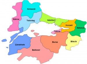
Marmara region

marmara_region

MarMara region connects Europe and Asia .


The Marmara Region (Tirkish: Marmara Bölgesi), with a surface area of 67.000 km², is the smallest but most densely populated of the Seven geographical regions of Turkey. It represents approximately 8.6% of the Turkish national territory and about 30% of its population.
This region was officially put in existence after the Geography Congress of 1941 in Ankara and is geographically divided into four regional parts, or areas.
Its name derives from the Sea of Marmara, which itself is named for the island of Marmara.
Look at the map of Marmara district. The region is divided between Europe and Asia. The region says history of forgotten children of Bharatvarsha. Look Istambul itself .It is central part of Marmara region.

Link to Marmara region

And History procced further……..


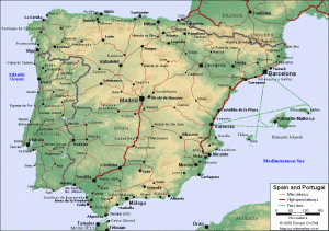
Castile and León
Or Kush and Lau?

Castile and León (Spanish: Castilla y León, Castiella y Llión) is an Autonomoous community in north-western Spain. It was so constituted in 1983 and it comprises the Hitorical regions of Leon and Old Castile (Spanish: Castilla la Vieja). It is the largest autonomous community in Spain, covering an area of 94,223 square kilometres (36,380 sq mi) with an official population of around 2.5 million (2005).
The organic law of Castile and León, under the Spanish Constitution of 1978, is the region’s Statute of Autonomy.. The statute lays out the basic laws of the region and defines a series of essential values and symbols of the inhabitants of Castile and León, such as their linguistic patrimony (the Castilian language, which English speakers commonly refer to simply as Spanish, as well as Leonese and Galician), as well as their historic, artistic, and natural patrimony. Other symbols alluded to are the coat of arms, flag, and banner; there is also allusion to a regional Anthem, though as of 2009 none has been adopted. April 23 is designated Castile and Leon Day, commemorating the defeat of the comuneros at the Battle of Villalar during the Revolt of the Comuneros
, in 1521.

Link
Merovech : Vishwa samrat Ram

Merovech (Latin: Meroveus or Merovius) is the semi-legendary founder of the Merovingian dynasty of the Salian Franks (although Chlodio may in fact be the founder), which later became the dominant Frankish tribe. He allegedly lived in the first half of the fifth century. His name is a Latinization of a form close to the Old High German given name Marwig, lit. “famed fight” (cf. mari “famous” + wig “fight”) compare modern Dutch mare “renowned” and vecht “fight”. The first Frankish royal dynasty called themselves Merovingians (“descendants of Meroveus”) after him.

The “Salian” in ” Salian Franks” may be a reference to Salt, a reminder of their pre-migration home on the shores of the North Sea (alternatively, it may refer to the Jsala or Ijssel river behind which their homeland, the Salland, may have been located.
Link

Historical explanations

Yes ,Alwar,Narwar and Kutwar are clue to world history. Alwar of India, Arzawa of Anatolia and Alawa of Poertugul are synonym term. In same way Kutwar of India ,Kut of Anatolia(Kizzuwatna) and Cumbria of Great Britain are synonym term. The connection between Navarre of Europe and Narwar of Madhya paradesh should be checked.
History of Anatolia mentions them as Luwian kingdoms. The history is very much right. Both kingdoms were clue to Kush of Ramayana. Kush …..the son of Ram…! This way presence of Kushvanshis (son of Ram) traced in Europe. They were partner in creation of Midland (Awadh).
Now no doubt ….London stands for Lau –nandan. History of Anatolia says history of Luwian kingdom Lydia too. Lydia was leader of Anatolia. Lydia is clue to Lau (One of the twin sons of Ramchandraji).No doubt now…Britain stands for Bahraich (Awadh). There is presence of Lau and Kush vanshis in Britain.
Now if you permit me I want to change name of My book to There is Ram. If you agree with me comment in Box and sugest me perfact name.
I think that now Book name should be “There is Ram”. But I shall not change it until I get your consent.

Site that carry similar facts

——————–
At the end of theresearch

Anarta / Anatolia /Atlantis

We have found lost continent of Atlantis

At the end of research we find that Anatolia was carrying history of ancient Anarta kingdom of Bharatvarsha. That Shryati founded in present day Gujarat. capital city of Anarta was Kushasttali.Kushasthali was beneath Ocean. WE have found Lost continent Atlantis. Now we find that original root word of Crete was Kursawar or Kussattar. .Shryati happened to be prior to Ram and river Saryu was named after Sharyati. Pl read The detail I mention in the chapter 7(1)

Link to Archaelogical findings of Kushsthali

LINK TO BOOK OF HELENE PETROVNA BLAVATSKY ( I WANT TO REMIND YOU THAT SHE HAS -NOT SOMETHING TO BUT EVERYTHING – TO DO WITH KRISHNA AND PAURTICULARLY BALDEV AND ANARTA)

Now if we find all these indian Royals in Anatolia..then it is not matter of Surprise.they were carrying their traditions only.

PL READ DETAILS IN CHAPTER -7(1) of Book section

Posted in A Book - There was Ram | Leave a comment

Chapter-7 :Lau and Kush vanshis in Anatolia 0r Aanarta of Sharyati (Gujarat) – son of Manu(1) Anarta= lost continent of Atlantis

Just as, there where its Maker shed His blood,
the sun shed its first rays, and Ebro lay
beneath high Libra, and the ninth hour’s rays
were scorching Ganges’ waves; so here, the sun
stood at the point of day’s departure when
God’s angel—happy—showed himself to us

Dante (Divine comedy)

Link to Divine Comedy

Arzawa (Luwia)
This was a poorly-recorded state with uncertain borders sited in the south-western corner of Anatolia. A large region composed of several principalities, it emerged during the dark age of the sixteenth century BC. The earliest Hittite records refer to both Arzawa and neighbouring Kizzuwatna as Luwia, so it is possible they emerged from a single territorial association. Arzawa had the Hittites as its immediate neighbour to the east, and the barbarian Kaskans and Pala to the north.
Arzawa ..clue to Alwar
Mycenaean states began to appear on the western coastline (including, perhaps, Ahhiyava), and in the mid to late fourteenth century BC the minor Luwian state (or vassal region) of Lukka lay to the immediate south. The north-western region of Wilusa was apparently Arzawan, but may have been independent of the Arzawan state itself, as it traditionally maintained friendly relations with the Hittites.
Link to Arzawa

Note: Pl look at site pictures. Trishl or Trident Symbol is clue to History. One can not deny that Trishul or Trident is Hisndu symbol. Open above site for second time and look at Symbol of Trident.

Kingdom of Mira

Probably the northernmost, the kingdom of Mira borders the Arzawan state of Masa (ruler unknown until about 1323 BC) and the kingdom of Wilusa, while south of it is the Seha River Land kingdom.
Link to Flute player sculpture

While the Hittite empire is destroyed, Arzawa is largely abandoned for at least a century, although in part the neo-Hittite kingdom of Maeonia emerges to take Arzawa’s place, along with the Phrygian kingdom.

Following book “Letters from the Hittite Kingdom
By Harry A. Hoffner, Gary M. Beckman” (p-314) can provide you further facts about Mira kingdom
Book link

Mirabai of India

Mira was their terminology. We know Mirabai, great devotee of Krishna .Mirabai was born a princess, a granddaughter of Rao Dudaji — the third son of Rao Jodhaji, who established the kingdom of Rathod Dynasty in Rajasthan, with Jodhpur as its capital in the kingdom known as Jodhpur. Jodhaji gave his son Rao Dudaji a small portion of the Jodhpur kingdom. It consisted of several villages with Medta as its capital. Medta is about 60 kilometers west of Ajmer in the present state of Rajasthan, India.
Rao Dudaji had two sons, Viramaji and Ratnasingh. Rao Viramaji had a son named Jayamal and Ratnasingh had a daughter called Mira, whose mother, Vir Kuvari, was the princess of Zola Rajput Sultan Singh.

There was state of Zalpa in Anatolia.
Link to Mirabai

Now let us check facts about state of Zalpa in Anatolia.
The state of Zalpa
Another probable aboriginal people in central Anatolia were those of the state of Zalpa. Like their neighbours, the Hatti, it is likely that they spoke a non- Indo- European language called Hattic which was probably related to the Circassian language group. Most of what is known of Zalpa comes from the Hittite ‘Proclamation of Anitta’.
Link to Zalpa

Kizzuwatna(second Luwian kingdom)

Kizzuwatna emerged from the ‘land of Adaniya’ (modern Adana) near the coast during the dark age of the sixteenth century BC, and was dominated by a mixture of Indo -European Luwians, Hittites from the north and Hurrians from the east. The earliest Hittite records refer to both Kizzuwatna and neighbouring Arzawa as Luwia, so it is possible they emerged from a single territorial association. Other regional peoples, such as the Teucri, also included Luwian elements amongst their make-up, showing how far they spread. Primarily a Hurrian state, with a capital at Kummanni, Kizzuwatna remained an independent power until the late fifteenth century, when it was conquered by Mittani.

The state supplies troops to various Hittite armies, including the one which now fights against Egypt at the battle of Kadesh/Qadesh. At some point in the late Hittite period, a people called the Danuna settle in Adaniya (with a possible relation to the Danya).

Note : Read above facts – Adaniya is not new term of Hinduism. You will get Adaniya Gotra in Rajashtan.
Link to Kizzuvatna
Now let us check Indian connections

Kutwar or Kizzuwatna ?

Kutwar, the erstwhile capital of Kachvah state, is an interesting place in Morena District of Madhya Pradesh. It is an explorable site for those who have an interest in archeology. Kutwar is about 22 km from Morena.
Kutwar is related with Kunti, the mother of the Pandavas. This place was known as Kuntibhoj in the age of Mahabharat.
There were many potteries and coins of the ‘Nag’ kings, ancient temples and monuments discovered during excavations in the village.
Places of tourist interest are the ancient Amba or Harrisiddhi Devi Temple and a crescent shaped Dam (built by the Scindia) erected on the Asan River.

Pl read this link……it is clue to History……
Link

Alwar or Arzawa ?
The princely state of Alwar was founded by Pratapsingh, a Pajput of the Kachwaha lineage, in 1770. His son, aided the British against the Marathas. After the battle of Laswari (1803) Alwar became the first state of Rajputana to sign a treaty of ‘Offensive and Defensive Alliance’ with the British East India company. During the Sepoy Mutiny of 1857, Raoraja Bane Singh sent a force consisting mainly of Muslims and Rajputs, to relieve the British garrison in Agra. The Muslims deserted and the rest were defeated by the rebels. Pran such Yadav, who fought beside Pao Tula Ram of Rewari in 1857, settled along with the kinsmen of dead soldiers at Village Nihalpura, Behror Tehsil, of Alwar District. Following the independence of India in 1947, Alwar acceded unto the Dominion of India.. On March 18, 1948, the state merged with three neighbouring princely states (Bharatpur,Dholpur and Karauli) to form the Matsya Union. This union in turn merged unto the Union of India. On May 15, 1949, it was united with certain other princely states and the territory of Ajmer to form the present-day Indian state of Rajasthan.
Link to Alwar
Do you not believe that Arzawa and Alwar has connection? Then read following facts.

Alwor in Portugul
Alvor tourism is popular because of the warm climate.
Alvor town is a very popular holiday location the enclosed narrow streets have kept development to a minimum. Many of these streets now boast bars with live music and different types of restaurants, however leading off from these there are still memories of the older fishing village.
Link -1

Link -2

Still you don’t believe then read following Link. Once more I want to remind you that no war can be faught for Money and Glory only. War reguire immense determimination and resolution. It is a matter of life and death.

We have seen facts about Kutwar of Madhya Pradesh (India) .Now read about Kutwar of Anatolia here………….

Kut War Cemetery

On the 6th August 1915 it was agreed that the Indian Expeditionary Force “D”, which in its advance inland had now reached Nasiriya, should advance on Kut; and on the 28th September, in the “Battle of Kut, 1915”, the Turkish covering forces were defeated. The Turks retreated, and the town was entered on the 29th. On the 11th November the advance was resumed; but in the Battle of Ctesiphon (22nd-24th November) it was brought to a standstill by severe casualties, and by the 3rd December the force was back in its entrenched camp at Kut. The Turks followed closely, and the Defence of Kut lasted from the 7th December to the 28th April, 1916. The troops besieged in Kut were the 6th (Poona) Division of the Indian Army, composed of British and Indian units, and certain other small detachments. They numbered 3,152 British and 8,455 Indian officers and men, and about 3,530 followers. In January, March and April, desperate attempts were made to reach the town and raise the siege; they were abandoned on the 26th April, after more than 23,000 officers and men had become casualties. Meanwhile the beleaguered force had suffered 3,776 casualties, including over 1,800 dead; and of the civil population (part of which had been allowed to remain) 247 had been killed or died of wounds. The garrison capitulated on the 29th April, 1916. Nearly 12,000 British and Indian soldiers and followers, weak and ill, were taken prisoners, and more than 4,000 of these died in enemy hands. The town was reoccupied by British troops in February 1917, and at the end of June it became an administrative, railway and hospital centre.

Yes Kutwar was that much Historically precious for them.They died and lived for It.
Link to Kutwar of Anatolia

Kachwaha or Cumbrian ?
Kachwaha are a Suryavanshi kshatriya clan who ruled a number of kingdoms and princely states in India such as Alwar,Maihar,Talcher, while the largest kingdom was Jaipur (Jainagara) which was founded by Maharaja Sawai Jaisingh II in 1727. The Maharaja of Jaipur is regarded as the head of the extended Kachwaha clan. The Kachhawas belongs to the Suryavanshi lineage, which claims descent from the ASurya (Sun Dynasty) or Suryavansha of the ancient Kshatriyas. They are descent from Raghav (Raghuvanshi) (Now you understand meaning of Rheghede kingdom of Wales?) as they claim descent from Kusha eldest of the twin sons of Rama, belongs to the Raghav clan, hero of the Ramayana, to whom patrilineal descent from Surya is in turn ascribed.
Link to Kachwaha

Rheghed (Raghav Kingdom)
Cumbria or Kurma / Kachwaha?

Rheged is described in poetic sources as one of the kingdoms of the Hen Ogledd (“Old North”), the Brythonic -speaking region of what is now Northern Endland and southern Scotland, during the Early Middle Ages. Its borders are not described in the poems, but some modern scholars have suggested that it included what is now Cumbria in North west England and possibly extended into Lancashire and Scotland. In the historical sources Rheged is intimately associated with the king Urien Rheghed and his family.[ Its inhabitants spoke Cumbric, a Brythonic dialect closely related to Old welsh
Yes Rheghade kingdom was Clue to Kush . They stand for Raghav and Cumbria stand for Kachhavaha (Tortoise)
WE shall discuss this topic in detail in the coming chapters about Kafir tribes and their migration towards west. Reghani tribe is clue to Rheghade or Raghav.
link to Reghed kingdom (Or Raghav kingdom?)

The Kachwaha, also spelled as Kachavaha, Kuchhwaha Kachhawa, Kacchavahas, Kushwaha, Kakutstha, Kacchapghata, and Kurma are a Suryavanshi Rajput clan who ruled a number of kingdoms and princely states in India.
Link -2
Cumberland
Now let us check facts about Cumberland. Cumberland is a Historic county of North west England, on the border with Scotland, from the 12th century until 1974. It formed an administrative county from 1889 to 1974 (excluding Carlisle from 1914) and now forms part of Cumbria.
Link to Cumberland

At the end of the period of British history known as Roman Britain (c. 410 AD) the inhabitants of Cumbria were Old welsh-speaking native “Romano-Britons” – probably descended from the Brigantes tribe which the Roman Empire had conquered in about 85AD. The Roman Civitas of the Carvetii (sometimes considered to be a sub-tribe of the Brigantes) covered almost the same area as what is now Cumbria. Because Cumbria was on the very edge of the Roman province of Britannia the term “Romano-Briton” is probably not a very accurate term for the people of these parts because despite more than three hundred years of Roman military occupation it is unlikely very many of them understood Latin or were particularly enthusiastic about Roman customs. The names “Cumbria” and “Cumberland” are derived from the name these people gave to themselves, and still do in Wales; Cymry (pronounced cum-ri) which originally meant ‘compatriots’ in Old welsh. The place names: Cymru, its Latinised version Cambria, Cumbria and Cumberland, all derive their names from this common root. The name could also be associated to that of the Sicambri who came with the Tungri as Auxiliaries in the 2nd and 3rd century.

Second Link

And History proceeds..
Alva or Alwar?
Álava or Araba is a province of Spain and a historical territory of the Bascqe Country, heir of the ancient Lord of Alava. Its capital city is Vitoria -Gasteiz which is also the capital of the autonomous community. It limits with the Basque provinces of Biscay and GIpuzkoa at north, the community of La Rioja at south, the Perovince of Burgos (in the community of Castile and Leon) at west and the community of Navarre at east, northern Spain.
It is the largest of the three Basque provinces, with 2.963 Km. and also the least populated with 317.352 inhabitants. The County of Trevino is an exclave of the province of Burgos (Castile and Leon) surrounded by Alavese land.

Castile (Spanish: Castilla) is a Spanish historical region of vague borders, which is the result of a gradual merge of the Kingdom of Castile with its neighbours to become the Crown of Castile and later the kingdom of Spain when united with the Crown of Aragon and the Kingdom of Navarre (Or Narwar of Madhyapradesh –India ?). In modern-day Spain, it is usually considered to comprise a part of the autonomous community of Castile and Leon in the north-west, and Castile –La Mansha and Madrid in the center and the central-south-west of the country, sometimes including Cantabria and La Rioja in the north as well, for historical reasons.. Modern Spanish monarchs are numbered according to the system of Castile.
Historically, the Castilian Kingdom and People were considered to be the main architects of the Spanish State by a process of expansion to the South against the Muslims and of marriages, wars, assimilation, and annexation of their smaller Eastern and Western neighbours. From the advent of the Bourbon Monarchy following the War of Spanish Succession until the arrival of parliamentary democracy in 1977, the Castilian language was the only one with official status in the Spanish state.

———————————————-

At the end of the research

Anarta of Sharyati and Anatolia

/ kursawar/ kursattar /Crete

Kushsthali was capital of Anart in Gujarat.

At the end of the research I have found that Anatolia carry history prior to Ram. In Fact I come to know that Sharyati son of Manu founded Anarta Kingdom in present day Gujrat.Anarta was son of Saryati. History of Anarta kingdom of Gujarat says that capital of Anart Kingdom of Sharyati was Kushasthali. It was History prior to Ram .Shree Ram happen to be 67 th succssesor to Manu. While Anart was fourth.

Anarta was named prior to Ram in Gujarat. It remained Anart until Dwapar yuga. Until Shri Krishna came from Mathura to Anarta of Gujrat.Then Kushsthali was named Dwarka. Dwarka was built on Kushsthali. It is history of present Gujarat province of Bharatvarsha.witt beginning of Kalyuga we forget that ancient Anarta.

Now It become very easy. History of Anatolia matches with ancient Indian Kingdom Anart. You will be surprised to knows that root word of Crete -foundation Island of Europe was / kursawar/or kursattar. Kushshthali was also remebered Here. So If we find Lavnandan here in Anatolia then it is not matter of surprise.

You can check the facts yourself.

Crete / kursawar/ kursattar

The island is first referred to as Kaptara in texts from the Syrian city of Mari dating from the 18th century BC, repeated later in Neo -Assyrian records and the Bible (Caphtor). It was also known in ancient Egyptian as Keftiu, strongly suggesting some form similar to both was the Minoan name for the island.
The current name of Crete first appears in Mycenaean Greek as ke-re-si-jo “Cretan” in Linear B texts. In Ancient, the name Crete first appears in Homer’s Odyssey. Its etymology is unknown. One speculative proposal derives it from a hypothetical Luvian word *kursatta (cf. kursawar “island”, kursattar “cutting, sliver”). In Latin, it became Creta.

Link to Crete of present Greece

We are surprised to know about Indian dynasties like Pala , Zala ,Haihaya and Luwian in Anatolia . But in fact we don’t know our own history…History of Bharatvarsha. So now let us know our own history…..the history of Satyuga , Treta and Dwapara. That history connect Anatolia with Anart…Greece with Gujarat, Hereclion with Halar and Crete with Kushsthali.
Let us begin with ancient Anarta of Bahratvarsha. Look how Anarta and Parthian history were connected.
First let us know our own history.

Anarta of pre Remayan time ( Satyuga)
Anarta / Kushasthali

Anarta was an ancient Indian region which corresponded to the present-day North Kathiyawar region of Gujarat state
According to the Puranic accounts, this region was ruled by the Sharyata dynasty rulers, who claimed their descent from Sharyati, a son of Vaivasvata Manu. The kingdom was named after Anarta, the son of Sharyati. The capital of this kingdom was Kushasthali (the ancient name of Dwarka). The last ruler of this dyansty was Kakudmi. After him, it was occupied by the Punyajana Rakshasas. Later, the Yadavas migrated to this region under the leadership of Krishna.
Sage Chyavana was also connected with Sharyati and Anarta. He married Suknya, daughter of Sharyati and sacrificed for him. His descendants were associated with the Haihayas, which occupied the neighbouring region, apparently after the demise of the Sharyata kingdom.
The Junagarh rock inscription of the Saka ruler Rudradaman mentions Anarta as a part of his kingdom. He placed Anarta under his Pahlava (Parthian) Amatya (minister) Suvishakha, who re-built a dam on the Sudarshana Lake ther.

Link to Anarta of present Gujrat of pre Ramayan period.

Link to archaelogical research of Kushasthali by S.R.Roa

Now HIstory of Apollo can be solved easily.

Aaplavaana / Apollo

The prominent personalities (pravara) mentioned in the puranas of this Bhrugu clan include: Bhargava, Chyavana, Aaplavaana, Aurava, Jamadagnya (Son of Jamadagni, Parusharama).
Bhrgu Contemporaries :

Bhrgu’s wife Pauloma was the mother of their son Chyavana.
Chyavana married Sukanya. Sukanya was Anarta’s sister.
Anarta was Raivata Kakudmin’s grandfather. Cyavana’s father-in-law, ie Sukanya’s father was Saryati, and his father was Vaivaswatha Manu.
That makes Saryati and Bhrgu: sambandhis or viyankulu.. (people whose children are married to each other.)

Link that explains Bhrugu Branch that live in south Gujarat.

Anarta of Mahabharat period

Anarta was a kingdom of ancient India, roughly forming the northern Gujarat state of India. It was ruled by Yadavas after they fled from Mathura of Sursena kingdom, due to the attacks of Jarasandha, the king of Magadha. The Yadava chiefs like Vasudeva Krishna, Balaram (brother of Krishna), Kritvarma and Satyaki, ruled this kingdom under their king Ugrasena. In Mahabharata, Dwaraka is considered as a capital city of Anarta Kingdom. But some other ancient texts like Mahabhagavata, mentions Dwarka and Anarta as two independent kingdoms. It can be concluded that, during the Mahabharata period, this kingdom was under the direct rule of the city-state of Dwarka which ruled a federation of many kingdoms. See also Dwarka Kingdom. As per the Purana viz. Bhagwat Purana, Bala Rama’s wife Revati was from this kingdom.

MBh. 3.182
When Pandavas were exiled to the woods, by the Kauravas, the five sons of Pandavas, born to Draupadi, were sent to Panchala, the kingdom ruled by their maternal grandfather Drupada. They later went to the Anarta Kingdom, ruled by the Yadvas, so that they can stay with their step brother and dear friend, Abhimanyu, and learn military science from eminent Yadava warriors.
Vasudeva Krishna’s words to Princess Krishna (alias Draupadi, Panchali):- Those sons of yours, are devoted to the study of the science of arms, are well-behaved and conduct themselves on the pattern of their righteous friends. Your father and your uterine brothers proffer them a kingdom and territories; but the boys find no joy in the house of Drupada, or in that of their maternal uncles. Safely proceeding to the land of the Anartas, they take the greatest delight in the study of the science of arms. Your sons enter the town of the Vrishnis (Vrishnis) and take an immediate liking to the people there. And as you would direct them to conduct themselves, or as the respected Kunti would do, so does Subhadra (their stepmother) direct them in a watchful way. Perhaps, she is still more careful of them. As Pradyumn is the preceptor of Aniruddha, of Abhimanyu, of Sunitha, and of Bhanu; so he is the preceptor and the refuge of your sons also! And a good preceptor, would unceasingly give them lessons in the wielding of maces and swords and bucklers, in missiles and in the arts of driving cars and of riding horses, being valiant. And he, Pradyumnna, the son of Rukmani, having bestowed a very good training upon them, and having taught them the art of using various weapons in a proper way, takes satisfaction at the valorous deeds of your sons, and of Abhimanyu. O daughter of Drupada! And when your son goes out, in pursuit of (out-door) sports, each one of them is followed thither by cars and horses and vehicles and elephants.’
The name Anatolia comes from the Greek Anatol? meaning the “East” or more literally “sunrise”, comparable to the Latin terms “Levant” or ” Orient” (and words for “east” in other languages). The precise reference of this term has varied over time, perhaps originally referring to the Ionian colonies on the west coast of Asia Minor.

Link to Anarta of Mahabharata period

Link to Anthony -reminder to Anarta

Now you understand history of Anatolia? (Anarta ?) so we find Lav nandan Here. Now we know that Shryati and Anart pahhen to be prior to Ram. River Saryu is named after Sharyati. They were carrying history of Ayodhya perior to Ganga Awatran (When river Ganges came on Earth from Heaven.) Now we also know that Sharyatiis descendents remained Allies of Haihaya. We find Ahhiyava in Anatolia. In India Haihaya founded Avanti. while Helvetti tribe founded Aventicum in present Switzerland.
In dwapar Krishna cane in Anarta pradesh of Gujrat. WE build Dwarka on Origin city of Kushsthali.Then we find Roxalian Sarmatia near Anatolia. Sramatia’s root word is Saurashtra.

Ahhiyawa
The most important Bronze Age kingdom in western Anatolia during the latter part of the thirteenth century BC was that of Ahhiyawa. Unfortunately, little is known of it, even down to its exact location and the origin of its people. While scholarly opinion is hotly divided, there may be a connection with the Mycenaeans, who certainly established commercial outposts on the Anatolian coast. The possibility is that they also established a political and military presence there, as a loose confederation of Mycenaean-period cities from the Greek mainland, Rhodes, and Thrace. The similarity between the names Ahhiyawa and Achaeans, the Homeric term for the Greeks of this period, has suggested this link since the kingdom’s existence was first discovered.

Seal of Antalya metropolitan municipality will tell you further story.
Seal of Anatya Metropolitan Municipality wii tell you history  Anaarta..son of Sharyati...who gave river name  Saryu.

Above seal and the word Antalya..dont remind you of anything?

Read about Antalya..It will lead you to Athens. Attalis tribe once dwelled at Athens.

Link to Antalya

Link to Antalya province

The Sarmatians /Sauromatæ

The Sarmatians (Latin: Sarmatæ or Sauromatæ, were anIranian prople of the classical antiquituy period, flourishing from about the 5th century BC to the 4th century AD. They spoke Scythian Language, an Indo European language from the Eastern Iranian family.
Their territory, which was known as Sarmatia to Greco –Roman ethnographers, corresponded to the western part of greater Scythia (mostly modern Ukraine,and Southern Russia, also to a smaller extent north eastern Balkans around Moldova). At their greatest reported extent, around 100 BC, these tribes ranged from the Vistula River to the mouth of the Danube and eastward to the Volga, bordering the shores of the Black and Caspian seas as well as the Caucasus to the south.

The Roxolani ( from Alanic ruxsalan- “bright alan” ) were a Sarmatian people, who are believed[] to be an off-shoot of the Alans. Their first recorded homeland lay between the Don and Drieper rivers; they migrated in the 1st century BC toward the Danube, to what is now the Baragan steppes in Romania.
The Greco -Roman historian Srabo (late 1st century BC-early 1st century AD) described them as “wagon -dwellers” (i.e. Nomads) (Geographika, Book VII).
Around 100 BC, they invaded the Crimea under their king Tasius in support of the Scythian warlord Palacus but were defeated by Diophantus, general of Mithradates VI.

Link to Sarmatian Kingdom

You will surprised to know that “katharevousa” was ancient language of Greece. (Does it means Kathiyawari? yes)

katharevousa

In Athens, the new capital, now that katharevousa had been accepted for official purposes, most hopes for the future were concentrated on ‘ennobling’ and ‘correcting’ everyday speech; outside the Iionian island (which would not become part of the Greek state until 1864), very few now argued for the use of ‘uncorrected’ demotic as the language of the state.
Among the believers in ‘correction’, hopes were still divided between those who pushed for the full resurrection of Ancient Greek (bringing with it Truth and Freedom, as Soutsos put it later), and the majority who believed with Korais that this was quite unrealistic, but that demotic could still be ‘corrected’ to the less demanding level of katharevousa. Both believed wholeheartedly in the power of the written language to transform the spoken one; they hoped that the ‘pure’ forms would naturally trickle-down to replace the ‘corrupted’ demotic ones, and that the spoken language would thus be pulled up to a ‘richer’ and ‘nobler’ level.
There was also a moral and spiritual side to linguistic ‘correction’. Korais had believed that “Because of their enslavement to foreign rulers, the Modern Greeks were incapable of thinking properly and thus of speaking properly; the correction of language would, however, lead to the correction of both thought and behaviour.”:109 It was hoped that as the damage done to the spoken language by centuries of subjection to ‘Oriental despotism’ was gradually repaired, the Greeks would begin to think more like their rational, critical and creative ancestors, and that the political and cultural life of the nation would thus be revitalized.
Katharevousa was widely used in public documents and whatever was conceived as work of formal activity by Greek scholars. In modern Greek colloquial connotation, the word katharevousa has come to mean “formal language”.

link to katharevousa language of Greece

Yes Katharevousa or Kathiyawadi was anciet language of Greece. The word Apollo and Ionia is evidence. The Roxolani is evidence. Because In Kathiyawar of Gujarat.. Aapa and Aai are most dignified word in present today. That two word lead us to Apollo and Ionia.How ? then read.

Apollo / Ayappa /“Hariharasuta” / Halstatt / Apaya or Apaga

Still “Apollo” obstruct you to realise the facts. you feel confused to listen the God Apollo. But I am not confused now. Because now I know “Vitruvianman ” and “Monalisa” depicted by Leonardo Da Vinci. Now I know that both has connection with Holy Grail. Now I know that Vitruvianman stand for Vitrahara = Indra..while Monalisa stand for Mohini. Still you can not realise it ? still confused? Then listen Apollo has connection with Ayappa.
Ayyappa is known as “Hariharasuta” because he is the son of Hari (VIshnu), the saviour and Hara (Shiva), the destroyer. His most common name is “Manikanta” because when the king Rajasekara Pandiyan of Pandalam found little Ayyappan in a forest, there was a “mani” (bell) tied around his neck.
As Dharma Sastha, many of them consider him to be born out of the union between Mohini (an Avatar of Vishnu) and shiva. Entire Kathiyawar , Halar and Suarahtra carry this word. The word “Appa” is clue to Ayyapa and Apollo. Appa is word for highest dignity in Saurashtra culture.
Secondly Europe was carrying Halstat culture. It also implies Hariharasuta” culture. It also prove that Aplolo and Ayappa was h Hariharasuta” aving same culture.
Now know about Ayappa – Hariharasuta”, Apollo and Halstatt culture? still doubt then read following facts.

Balarama journey to Sarswati

Balarama started from Dwaraka and traveled along Gomati to reach Saraswati. This region where Saraswati and its dis-tributaries join the sea was known as Prabhasa. From here he went to Chamasodbheda where Saraswati flowed due to rain water collected from Arbuda mountains. (Arbuda means ten-thousand, referring to a hilly region with 10,000 hills). Then he went to Udapana. From here own towards towards north Saraswati existed only as a dried up channel:- Although the Sarasvati seems to be lost there, yet persons crowned with ascetic success, in consequence of their obtaining great merits and great blessedness at that spot, and owing also to the coolness of the herbs and of the land there, know that the river has an invisible current, through the bowels of the earth there. Some people considered that Saraswati existed here underground by seeing the greenery along its course.

Link to Balarama’s journey to river Sarswati.
In above link you can read about Apaya or Apaga tirth near Kurukshetra.

Apaya or Apaga

(Therefore, O Rajendra (king) there after one should go to famous holy place, Manusa Tirtha The herbs of black dears, wounded with the arrows of the hunter, after bathing in this pond, have attained the man – from. For this, it is called Manisa Tirtha. A devotee, following the order of celibacy and having complete control on his mind and heart, after bathing in this pool becomes sin-free and finds place in heaven.)
Some scholars opine that Manusa holy place is linked with Apaga sanctum near Kurukshetra’s Karnajheela (a huge pond). Factually, the location of Apaya or Apaga at a distance of one km is accepted by Mahabharata and Purana both respectively.

`Manusasya to puruena koshamatra Mahipte |
Apaga nama vikhyata nadi siddhanivesita. ||’
Mahabharata – Vanaparva 83\67.

Manasa is situated in the east, one mile away from Apaga ( now a Government canal ). Residents of the nearby area, accepting this canal as Saraswati, bathe in it and perform rituals on holy occasions. Old record of irrigation department calls it as Saraswati. Therefore, old Apaya’s or Apaga’s rocking waves flow-path was here. Keeping in view all this data, it remains proved that `Manasa’ is the name of Rigvaidika village `Manusa’ and the existance of Apaya or Apaga, at a distance of one km, is an established fact without any controversy.

Mythology says that Kaithal still carry tradition of Tirthas or places of Sarswati river . let us know about Kaithal (Cathdral?)
Kaithal is a city and a municipal Council in Kaithal district in the Indian state of Haryana. Kaithal was previously a part of Karnal district and later, Kurukshetra District until 1 November 1989, when it became the headquarters of the Kaithal district. Of Haryana. Kaithal shares common boundary
with Patiala (Punjab), Kurukshetra ,Jind and Karnal.

Garry Champawat / Greece / Gujarat

Now we can Easily understand that The original word Garry Champat from KUmaon (Uttarkhand) come out to Travel in the word. When the word reached in Bhartvasha itself the word Gerry Champawat turned to Guajrat..while..when the word reached the another continent..it turned to Greece. In The same way when the word Apaya or Apaga travelled from Sarswati river it turned to Ayappa when reached South India..when reached another continent ..it turned to Apollo.

The Halstatt culture of Devashchland is in fact “Hariharasuta” culture of Ayappa / Apollo.

Link to etymology of Greece (As per my opinion it is Guajarat)

Ayyappan

Ayyappan (also called Sastavu, or Sasta) is a Hindu deity worshiped in a number of shrines across India. Ayyappan is believed to be an incarnation of Dharma Sasta, who is the offspring of Shiva and Vishnu (as Mohini, is the only female avatar of the God Vishnu ) and is generally depicted in a yogic Posture, wearing a jewel around his neck, hence named Manikantan. Ayyappan may bear a historical relationship to the tutelary Deity Aiyanger in Tamilnadu.
Ayyappa is known as “Hariharasuta” because he is the son of Hari (Vishnu), the saviour and Hara (Shiva), the destroyer. His most common name is “Manikanta” because when the king Rajasekara Pandiyan of Pandalam found little Ayyappan in a forest, there was a “mani” (bell) tied around his neck. As Dharma Sastha, many of them consider him to be born out of the union between Mohini (an avatar of Vishnu) and Shiva.

Link to Ayyappan culture

Apulu./ Apollo

Apollo (Doric: Apell?n; Apeil?n; Aploun; Latin: Apoll?) is one of the most important and complex of the Olympian Deities in ancient Greek and Roamn Region, Greek and RomanMythology, The ideal of the Kowros (a beardless, athletic youth), Apollo has been variously recognized as a god of light and the sun, truth and prophecy, healing, plague, music, poetry, and more. Apollo is the son of Zeus and Leto, and has a twin sister, the chaste huntress Artemis. Apollo is known in Greek-influenced Etruscan myrthology as Apulu.
The etymology of Apollo is uncertain. The spelling had almost superseded all other forms by the beginning of the common era, but the Doric form is more archaic, derived from an earlier The name is certainly cognate with the Doric month and the Doric festival .
Several instances of Popular etymology are attested from ancient authors. Thus, the Greeks most often associated Apollo’s name with the Greek verb, “to destroy”. Plato in Cratylus connects the name with (apolysis), “redeem”, with (apolousis), “purification”, and with (aploun), “simple”,[5] in particular in reference to the Thessalian form of the name, ??????, and finally with ???-?????? (aeiballon).
Among the proposed etymologies is the Hurian and Hittite divinity, Aplu, who was widely invoked during the “plague years”. Aplu, it is suggested, comes from the Akkadian Aplu Enlil, meaning “the son of Enlil”, a title that was given to the god Nergal, who was linked to Shamash, Babylonian god of the sun

Link to Apollo.

History is clear now. Lord Apolo or Ayappa also clarifies concept of Michel Angelo. His famous POtrait of Monasila called for one more incarnation of Mohini. His potraite of Vitruvianman called for one more incarnation for Vitrahara..Slair of Vitra.

Link to ancient Crete

Link that talk about Anatolia and Crete

Link to Kushsthali..upon this city..Krishna developed Dwarka

History of Dwarka / Kushsthali

The Book “The Secret Doctrine: Synthesis of Science, Religion and Philosophy Part 5”
By Helene Petrovna Blavatsky (p- 256) narrates mysterious marriage of Ravati with Balram

Link to the Book The Secret Doctrine.

Link to Genealogy of shri Ram

The book “Encyclopaedia of Tourism: Resources in India”
By Manohar Sajnani (p-82) also mentions..Sarswat Brahmin carry history of Kushsthali. History of Sharyati says that letteron they turned to Brahmin. When reguired at time of Rakshsa attack his son again turned to Kashtriya.

Book link The book “Encyclopaedia of Tourism: Resources in India”

Link to Knossos Palace in Crete

Link to Heraclian (Kastro castle)

Link to Cstros in Cyprus

Link to Castro culture

Anarta = Enotoi = Veneti tribe = Venice

Miletus = Haneti = Haihaya of Malva (Avanti)

The Book “Mededelingen Van Het Nederlands Instituut Te Rome: Antiquity”
By Nederlands instituut (Rome) (p-15) mentions Adratic Enetoi people alongwith Miletus.
Now we know that descendent of Anarta ( son of Sharyati..Grandson of Manu ) merged with Haihaya people who founded Avanti in Malva.

Now we find Enetoi people alongwith Miletus in Italy and Adraitaic sea. Enetoi people letteron known as Veneti people. Venice is maned after people of Anarta.
With this clarification now it is clear. Enetoi were descendent of Anarta. Veneti celtic tribe is also Suryavanshi (Sunline – Iscvone = Ikshvakuvanshi)
Sharyati = river Saryu
We have to remember that Sharyati was son of Ikshvaku. River Saryu at Ayodhya named behind Sharyati . We have to remember Sharyati happen to be long before Ram and Ganga Awataran. Saryu existed before Ganges. Sharyati and Anarta carry history of Ayodhya.

Book link “Mededelingen Van Het Nederlands Instituut Te Rome: Antiquity”
Link to Adriatic Veneti tribe.Venice is named behind trhis tribe.

Kayastha
Says they had liniege with Haihaya. Anarta and Kushthali also merged with Haihaya. Shri Vatsa Gotra says history of Chyawan Rushi. Daughter of Sharyati marry to Chyavan Rushi. All these factors connect them Kushsthali….Kayastha..! Kayastha should go deep into the history of Kushsthali and Sharyati.

Link to Kayastha

Kaithi language and Kaystha

God / Gauda : The mysterious word of Sarswati river culture

And it has its origin in Kushsthali ?

THE FOUNDING OF GAUDA PADACHARYA MUTT:
It is well known to us that His Holiness Gauda Padacharya was the originator of Ashram Mutt Parampara in Goa and all the sarawats were originally Smarthas following the Smartha philosophy. Shiva, Vishnu, Ganapathi, Shakthi, Suryanarayana are the Gods called as Panchayatana being worshiped by them. The present Kavale Mutt which had been originally founded at Kushasthali where (C.740 AD) by the third “yati” H.H.Shri Shri Vivaranananda Saraswathi Swamiji’s who was one of the two disciples of H.H. Shri Shri Govinda Bhagavath Padacharya, the disciple of Shrimad Poojyapada Gaudapadacharya. The other disciple of H.H. Shri. Shri. Govinda Bhagawathpadacharya was the Adi Shankara Acharya, who was blessed and initiated into Sanyas Deeksha. He propagated the adwaitha Philosophy of Gaudapadacharya throughout the length and breadth of India and founded the four Mutts at Badari, Dwaraka, Puri and Shringeri, thus starting his own parampara.

The original Gaudapadacharya Math founded at Kushsthali

The original Gaudapadacharya Math founded at Kushsthali, was destroyed during the Portuguese rule in Goa during around 1564 AD. Later it was shifted to Kaivalyapura (Kavale) in and around 1630 AD.
The Kaivalya Math has a great parampara and history. All the Saraswats that is to say, the different sub-sects, as mentioned earlier, were the followers of this ancient Math and of Rigvedi Shakala Shakheeya Ashwalayana Sutris. They were of Smartha Tradition following the Math’s adwaitha philosophy. The present sub-sect-Rajapur/Balawalikar Gaud Saraswath Brahmanas were the original settlers of Gomantak and are the integral part of Saraswath Brahmanas of “Saraswat Desh” who finally came to settle down there in “Agraharas” which mean the settlements of Brahmanas not only performing religious functions and pursuing academic activities but also guiding the community in various professions. These “Agraharas” were patronized by rulers, queens and generals and also by affluent sections of the community. Scholarly brahmanas were invited to these ‘agraharas’ to settle down by granting them lands, excavating tanks and building temples which act was considered as bringing one merit or ‘punya’. These ‘Agraharas’ were situated amidst a cluster of villages to serve the people. No wonder Saraswat Brahmanas who were intelligent and scholars were also assigned governmental functions and others who were enterprising engaged themselves in trade, agriculture with the Satavahanas, Kadambas of Goan branch, down to Vijaynagar rulers and their subordinates. Thus many became ministers, Desais, Kulakarnis, Nadkarnies, village accountants (Shenais), Clerks, army generals and lesser officials in the army and some even became the heads of administration. Thus, it is believed that certain surnames of the Saraswat Brahmanas like Prabhu, Kamath, Nayak, Desai, Kulkarni, Nadkarni, Shenai etc. indicate their professional career names.

Link to Sarswat Gauda Brahmin and Kusthali connection

Link that explains European word Gaud

Gauda :Indian term

“Studies In The Geography Of Ancient And Medieval India”
By D. C. Sircar (p-119) also explain the Indian term Gauda. There was Gaud Kingdom too in India. secondly Chaitnya Maha prabhuu also came from Gaud area…area in Bengal. There should be some conection between this Gaud and God. Because here we find Hougly while in Devshchland we find Hague.
Book link that explains gaud geography

Athenai / Athens / Athena Parthenos

Ath?nai / Athens / Athena Parthenos / Ashapura Carry history of Anarta…We people of India forget history of Anarta and Sharyati, who named river Saryu. We people forget history of Anarta where Krishna came from Mathura … We people forget history of Lavnandan. Is it not suprising ? We claim that we owe Manu and Ayodhya…But we are not ready to remember who named Saryu. We claim Ram but not ready to remember Lav nandan.
They remember everything..we forget everything. It is time to interospect. Why we forget everything? Why we want to forget everything?We claim culture..we claim heritaje..but not ready to remember originator. We forget Anarta so are disconnected. They know our habits. They know our habits sinsce Anarta….So Lav nandan is there in Britain..far away from India. Because he knows Britain will ever care for Him..Bharat will never care..never…! We failed in all the litmus testes…God knows where we shall pull our history?

Link to Athena /Athena Parthenos / Ashapura
Link to Athens

Minoan or Mevadi ?

The history of Crete ,kushasthali remembers first Minoan civilization. That Mimoan civilization is clue to Etruscan culture, where remains of Ram ,Laxman ,Janki pictures were found. Means Lavnandan enered his ancestral sit of Kushsthali…The new culture was named Minoan….Sir it is Mevadi culture they are talking about.

Means during their reing Lav vanshis took control of Capital City of Anarta , Kushstali…Crete…Minoan people were mentioned in Odyssey..that says migration story of Awadhvanshis…Awadh. Mimoan people are clue to Mevad.

Link to Knossos (Kaushal) that Lavvanshi founded on Crete (Kushsthali),their ancestral Throne. There was ancient mound near Knossos named Kephala (Kushsthali).

Yes..Sharyati…( River Saryu named after Sharyati)..and his son Anarta was remembered there…So it became Ancestral throne for Lavvanshi.
They took charge of their ancestral throne.It was very natural process.

And History proceed further…to..Milan

Link to Milan of present Italy

Prior to read world History..read about King Manu maharaj….of Ayodhya..No he was not told King of Bharatvarsha…Manu was King of the world.

Link to the Book “Encyclopaedia of the Hindu World: A-Aj, Volume 1”
edited by Gaaga Ram Garg will explain you evrything.

Anarta in Art book

“History of Indian Theatre, Volume 2 ” By Manohar Laxman Varadpande also remember Anarta.

The book link will explain you everything

Taranga hill / Tara hill

In ancient Anarta pradesh we find Taranga hill and the people who ever remebered Anarta…That is Ireland..we find Tara hill. History and struscture of Tara hill and Tara hill should be checked.

Book link to “Ancient Indian Social History: Some Interpretations”
By Romila Thapar

Vadnagar carry history of ancient Anarta ? Large kingdom from Patan ..Prabhas Patan to Greece?

Link to Vadnagar city that carry history of Anarta.

In fact Alexander the Great was the last ruler who brohght entire Anarta Kingdom into its ancient form…He came from opposite end of Anarta..so we could not recognise him…But It is historical reality…He uniterd entire ancient Amarta kingdom.

kUSHSTHALI – CAPITAL OF ANARTA BENEATH OCEAN AND ATLANIS

Kakudmi (sometimes also called Kakudmin, or Raivata, son of Revata) was the King of kUSASTHALI, a kingdom beneath the ocean. He was the father of Revati, who married Balrama. Within Hinduism, his account is given within a number of Puranic texts such as the Mah?bh?rata, the Devi Bhagavatam and the Bhagvata Purana.
King Revata constructed the city of KUsasthali beneath the ocean and ruled from there. Kusasthali grew to became a prosperous and advanced kingdom. From Kusasthali, he also ruled over large tracts of land, including Anarta kingdom, which was named after his father.
Revata had one hundred sons of whom Kakudmi (also called Raivata, son of Revata) was the eldes

Link to Kusasthali , capital of Anarta beneath ocean

Atlantis that sank into the ocean

Atlantis ( “island of Atlas”) is a legendry island first mentioned in Plato’s’s dialogues Timaesus and Critias, written about 360 BC. According to Plato, Atlantis was a Naval power lying “in front of the Pillars of Hercules” that conquered many parts of Western Europe and Africa 9,000 years before the time of Solon, or approximately 9600 BC. After a failed attempt to invade Athens, Atlantis sank into the ocean “in a single day and night of misfortune”.
Scholars dispute whether and how much Plato’s story or account was inspired by older traditions. In Critias, Plato claims that his accounts of ancient Athens and Atlantis stem from a visit to Egypt by the legendary Athenian lawgiver Solon in the 6th century BC. In Egypt, Solon met a priest of Sais, who translated the history of ancient Athens and Atlantis, recorded on papyri in Fgyptian hieroglyphs, into Greek. Some scholars argue Plato drew upon memories of past events such as the Thera eruption or the Trojan war, while others insist that he took inspiration from contemporary events like the destruction of Helike in 373 BC or the failed Athenian invasion of Sicily in 415–413 BC.

Link to Atlantis says that Atlas says the history of Anarta…son of Shryati

Link to Anarta in Mahabharata

Link to the book “Atlantis: The Lost Continent Finally Found” By Arysio Santos

What Madam Blavatsky says..

Theosophist Helen Petrovna Blavatksy’s noted book ” The Secret doctrine” will explain you further story. The narration in section -28 ( The origin of Mysteries) page 258 will explain you evrything that I can not explain..Believe each word true. Because we find Mantua (Mathura) in Italy and Dhenkanal is root word of Geveva. pl read the pages and know history of Helvetii tribe of Europe. Present switzerland in ancient time was called Helvetia..the tribe founded there Avanticum.

Book Link to “The secret doctrine”

Shanta Durga temple
carry tradition of Kushasthali

Ya Shanta Kula carry history of Kushsthali, a capital beneath ocean. They still remember kushsthali. Look the word “kushsthali” turned to Cortalim in Bahartvarsha itself.

Link to Shanta durga temple at Kushasthali (Goa). Look at design of temple and design of dipmala carefully.
Link to Cortalim of Goa

Antruz Mahal (Memory of Anarta)

Ponda, known as Antruz Mahal because of the concentration of culture, music, drama and poetry also houses the temples. The busy inland town of Ponda, about 29 kms southeast of Panaji, and 17 kms north-east of Margao is home to a number of unique Hindu temples and several spice plantations

Link to Ponda or Anatruz Mahal

Etruscan civilization

Etruscan civilization is the modern English name given to a civilization of ancient Italy in the area corresponding roughly to Tuscany ,western Umbria, and northern Latinum. The ancient Romans called its creators the Tusci or Etrusci. Their Roman name is the origin of the terms Tuscany, which refers to their heartland, and Etruria, which can refer to their wider region.
In Attic Greek, the Etruscans were known as Tuppnvoi), earlier Tyrsenoi, from which the Romans derived the names Tyrrhani (Etruscans), Tyrrh?nia (Etruria), and Mare Tyrrh?num. The Etruscans called themselves Rasenna, which was Syncopated to Rasna or Rasna.

Link to Etruscan civilization

lINK TO ETURNAGRAM OF WARANGAL

Kukudmi / Cymru / Kumaon / Khas

Reivata or Kukudmi married his daughter with Balrama went to Badrinath. Then we don’t know anything about Kukudmi. Is it possible that Khas people are descendent of Kukudmi ? Khas people who dwel in Kumaon are descendent of Kukudmi ? So they are Khas ? Mansadevi , their Goddess has connection with Manusa sarswati tirth ?

Now read the facts from following book link . The book talk about low water level in Arabian sea.The book talk about many structures beneath ocean.
Link to the Book “Legacy of the Gods” By Freddy Silva (p-76 )

Now look at the link about Atlantis.…and go deeper into Atlantis

KuKudmi / Kumaon

Kukudmi or Raivata married his daughter Revati with Balrama and went Badrinath for Tapashchrya. Then History of Kumaon begin. Kingdom of Almora..emerge and spread in to the world. Now connection between Kukudmi ( Last Suryavanshi king of Anarta) and Kumaon should be checked.

Link to Kukdmi ( last Sunline ruler of Anarta)

Link to Anarta near Ethopia .The link says story of Anrata , a coastal village in eastern Eritrea.

Sparta / Soparaka

Sparta or Lacedaemon, was a prominent city state in ancient Greece, situated on the banks of the Eurotas River in Laconia, in south-eastern Peloponnese. It emerged as a political entity around the 10th century BC, when the invading Dorians subjugated the local, non-Dorian population. During c. 650 BC, it rose to become the dominant military land-power in ancient Greece.
Given its military pre-eminence, Sparta was recognized as the overall leader of the combined Greek forces during the Greco –persian wars. Between 431 and 404 BC, Sparta was the principal enemy of Athens during the Peloponnesian war, from which it emerged victorious, though at great cost. Sparta’s defeat by Thebes in battle of Leuctra in 371 BC ended Sparta’s prominent role in Greece. However, it maintained its political independence until the Roman conquest of Greece in 149 BC. It then underwent a long period of decline, especially in the Middle ages, when many Spartans moved to live in Mystras. Modern Sparta is the capital of the Greek regional unit of Laconia and a center for the processing of goods such as citrus and olives.
Sparta was unique in ancient Greece for its social system and constitution, which completely focused on military training and excellence. Its inhabitants were classified as Spariates (Spartan citizens, who enjoyed full rights), Mothakes (non-Spartan free men raised as Spartans), Periokoi (freedmen), and Helots (state-owned serfs, enslaved non-Spartan local population). Spartiates underwent the rigorous Agoge training and education regimen, and Spartan Phalages were widely considered to be among the best in battle. Spartan women enjoyed considerably more rights and equality to men than elsewhere in the classical world. ( Now you have to understand meaning of Phoenicians…read about Sopara (Maharashtra) and try to understand meaning of Phenicians )

Link to Sparta of Greece

Sopara -land of Parshurama

Sopara (or Soparaka (by some identified with the Ophir mentioned in the Hebrew texts texts) was an ancient port town and the capital of the ancient Aparanta. The site of this ancient town is located near the present day Nala Sopara town in the Thane district of the stateMaharashtra,India. Nala Sopara is one of the busiest western suburbs of Mumbai city. In ancient times, it was the largest township on India’s west coast, trading with Mesopotamia ,Egypt ,cochin ,Arabia and Eastern Africa.
The Mahabharata and the Purans state that the ??rp?raka was reclaimed from the sea for the dwelling place of Parashurama and it became a tirtha for this reason. The finding of the relics in a stupa and the rock edicts (the fragments of the 8th and 9th major rock edicts) of Ashoka in 1882[ prove the importance of this port town from the 3rd century BCEto the 9th century CE.

Link to Sopara or Soparnaka (Now understand meaning of Parkar?)

Aparanta / Aparantaka / Africa

Aparanta, or Aparantaka (meaning “Western border”) was a geographical region of ancient India, variously corresponding to the northern Konkan, northern Gujarat, Kathiawar, Kachch and Sindha.
The Junagadh inscription of Rudradaman mentions that during Ashoka’s reign, a Yonaraja (Persian), Tushaspa was the governor of Aparanta.

Link to Aparanta Kingdom

Aprica

Afri was a Latin name used to refer to the Carthaginians, who dwelt in North Africa in modern-day Tunisia. This name seems to have referred to a native Libyan tribe .. The name is usually connected with Phoenician afar, “dust”, but a 1981 hypothesis has asserted that it stems from the Berber word ifri (plural ifran) meaning “cave”, in reference to cave dwellers. The same word may be found in the name of the Banu Ifran from Algeria and Tripolitania, a Berber tribe originally from Yafran (also known as Ifrane) in northwestern Libya.
• the 1st century Jewish historian Flavius josephus (Ant. 1.15) asserted that it was named for Eopher, grandson of Abraham according to Gen. 25:4, whose descendants, he claimed, had invaded Libya.
• Latin word aprica (“sunny”) mentioned by Isidore of Seville in etymologiae XIV.5.2.
• the Greek word aphrike meaning “without cold.” This was proposed by historian Leo Africanus (1488–1554), who suggested the Greek word phrike ( meaning “cold and horror”), combined with the privative prefix “A”, thus indicating a land free of cold and horror.
• Another theory is that the word aphrikè comes from aphròs, ‘foam’ and Aphrikè, ‘land of foam’, meaning the land of the big waves (like Attica, from the word aktè, Aktikè meaning land of the coasts).

Link to Africa ..that has roots in Aparanta

Link to Aparayogana continent
….. >…..
ANARTA /ANATOLIA

AT THE END OF THE RESEARCH WE FIND THAT ANARTA KINGDOM FOUNDED BY sHARYATI..BROTHER OF IKSHVAKU REMEMBERED IN FORM OF ANATOLIA IN WEST…KUSHSTHALI IS REMEMBERED IN FORM OF CRETE. ANARTA WAS VERY LARGE KINGDOM..BEYOND OUR IMAGINATION. ANARTA WAS FOUNDED IN SATYUGA BEFORE SHRI RAM AND GANGA AVATARAN. kUSHSTHALI WAS CAPITAL BEMEATH THE OCEAN. SO IT IS VERY NATURAL THAT LAV KUSH REACHED ANATOLIA…IT WAS NATURAL PROCESS.

lINK TO KUSHTHALI ARCHEAOLOGY

LINK TO THE BOOK BY HELENE PETROVNA BLAVATSKY (I WANT TO REMIND YOU THAT BLVATSKY HAS -NOT ONLY SOMETHING BUT EVRYTHING TO DO -WITH KRISHNA AND PARTICULARLY WITH BALDEVA AND ANARTA)READ PAGE 259

—————————-
Tamils who migrated from Sarswati river civilization in to south keep entire History..It shawas that after Sarsawti river dried people migrated in all four direction..in leadrship of Vasudevrai (single name of all leaders…

Link to Pagal Pathu will explain you all terminology mentioned in this article from begining to end. Arzwa , Alwar all are Tamil terminology..is it ?
It proves That Sanctum sedes stand for Sehsnchalam……..same was Sachsen -Anhalt (Saxony -Anhalt) also stand for seshanchalam..at last saxons reached Wales and Britain….There was Ram..

AFTER RAM NOW LAV KUSH IN VANVAS..
KINGDOM OF CASTILE CLUE TO kUSH AND kINGDOM OF LEUVEN..LEON..LOVIA CLUE TO LAV NANDAN.

Posted in A Book - There was Ram | Leave a comment

Anatolia: Pala or Ashtdikpala ?(3) : Anatolia or Anarta of Sharyati in Gujarat? Anarta = lost continent Atlantis: Parikar /Parkar : Seven Hills : Sapt shrunga

Pala in Anatolia as well as In India

Pragjyotisa / Phrygia / Paharpur / Paphlagonia

We find Pragjyotisa in ancient India (present Assam) , while Phrygia in Anatolia. We can trace out Pala dynasty presence in both the kingdoms.Gordium was Capital city of Phrygia while Gaor was capital city of Palas in India. The facts again put me in Dilema. Shoud I begin with Pragjyotisha or Phrygia? If I begin with Phrygia (Anatolia) then you will feel it very remote. So let us begin with Pragjyotisha (Assam).

Pragjyotisha

Pragjyotisha was a mythological kingdom first mentioned in the Hindu epics and later Hindu literature. According to later versions of the epic, King Bhagadatta ruled the kingdom during the time of the Kurukshetra war where he met his death. In historical times, it came to be named as the Kamrupa Kingdom. Much of the mythical kingdom is culled from the 10th century Kalika purana and the later Yogini Tantra. The kingdom roughly falls in modern-day Assam in India.

Link to Pragjyotisha

Kamarupa was previously called Pragjyotisha, was the first historical kingdom in Assam that existed between 350 and 1140 CE i.e for almost 800 years. Ruled by three dynasties from their capitals in present-day Guwahati and Tezpur, it covered the entire Brahmputra river valley and, at times, North Bengal and parts of Bangladesh. The region is mentioned as Pragjyotisha in the Mahabharata and the Ramayana. The Periplus of the Erythraean Sea (1st century) and Ptolemy’s Geographia (2nd century) calls the region Kirrhadia after the Kirata population.
After the death of Tyagasimha without an heir, a member of the Bhauma family, Brahmapala (900-920), was elected as king by the ruling chieftains, just as Gopala of the Pala dynasty of Bengal was elected. The original capital of this dynasty was Hadapeshvara, and was shifted to Durjaya built by Ratnapala, near modern Guwahati. The greatest of the Pala kings, Dharmapala had his capital at Kamarupanagara, now identified with North Guwahati. The last Pala king was Jayapala (1075-1100). Around this time, Kamarupa was attacked and the western portion was conquered by the Pala king of Gaur Ramapala.

Link– Pragjyotisha

More link

The Following link to the book “Encyclopedia of North-East India
By Col Ved Prakash
“(P- 145) will say you story of History Pala dynasty rule in North –East India

Book -Link

Pala presence in Anatolia

The Indo-European migrations, which took place over a vast territory extending from Western Europe to India, brought some peoples over the Caucasus into Anatolia. The Nesi people settled in Central Anatolia, the Pala in Paphlygonia, and the Luwians in Southern Anatolia.

Pala presence in Anatolia

Hittite rule map clearly mentions Pala


In the course of these migrations the new arrivals gradually captured the Hatti princedoms to form first the Old Hittite Kingdom (1660-1460 B.C.), and than the Great Hittite Kingdom(1460-1190 B.C.).

Link
Palaic is an extinct Indo -European language, attested in Cuniform tablets in Bronze Age Hattusa, the capital of the Hittites. Its name in Hittite is palaumnili, or “of the people of Pala”; Pala was probably to the northwest of the Hittite core area, so in the northwest of present mainland Turkey. That region was overrun by the Kaskas (Khas or Kirata?) in the 15th century BC, and the language likely went out of daily use at that time.
Link

History of Anatolia says that Paphlygonia (Of Pala) was separated from Prygia. Secondly the following links also gives evidences of Pala presence in Anatolia.. Go through this link and then go for Phrygia and Paphlagonia. If possible read history of Pala dynasty of Hindustan. Yes first you have to know about Pala dynasty of India. That information will help you to historical connection.

Second link

Phrygia

In antiquity, Phrygia was a kingdom in the west central part of Anatolia, in what is now modern-day Turky, centered around the Sakarya River.
The Phrygians are most famous for their legendary kings of the Heroic age of Greek mythology: Gordias whose Gordian Knot would later be untied by Alexander the Great, Midas who turned whatever he touched to gold, and Mygdon who warred with the Amazons (Warrior band of women). According to Homer’s Iliad, the Phrygians were close allies of the Trojans and participants in the Trojan war against the Greeks. Phrygian power reached its zenith in the late 8th century BC under another, historical King Midas, who dominated most of western and central Anatolia and rivaled Assyria and Urartu for power in eastern Anatolia. This later Midas was however also the last independent king of Phrygia before its capital Gordium was sacked by Cimmerians around 695 BC. Phrygia then became subject to Lydia, and then successively to Persia, Alexander and his Hellenistic successors, Pergamon, Rome and ByZantium. Phrygians were gradually assimilated into other cultures by the early medieval era, and the name Phrygia passed out of usage as a territorial designation after the Turkish conquest of Anatolia.
King Priam married a Phrygian princess, Hecuba, and maintained a close alliance with the Phrygians, who repaid him by fighting “ardently” in the Trojan War against the Greeks.
Link

Paphlagonia was an ancient area on the Black Sea coast of north central Anatolia, situated between Bithynia to the west and Pontus to the east, and separated from Phrygia (later, Galatia) by a prolongation to the east of the Bithynian Olympus. According to Strabo, the river Parthenius formed the western limit of the region, and it was bounded on the east by the Halys river.

Link

Gordium – capital of Phrygia
Gordium (Greek: Górdion; Turkish: Gordiyon) was the Capital city of ancient Phrygia. It was located at the site of modern Yassihuyuk, about 70–80 km southwest of Ankara (capital of Turkey), in the immediate vicinity of Polati district. The site was excavated by Gustav and Alfred Körte in 1900 and then by the University of Pennsylvania Museum, under the direction of Rodney S. Young, between 1950 and 1973. Excavations have continued at the site under the auspices of the University of Pennsylvania Museum with an international team.
Gordium lies where the ancient road between Lydia and Assyria/ Babylonia crossed the Sangarius river.

In the twelfth century BCE, Gordium was settled by Thracians who had migrated from South eastern Europe. During the ninth and eighth centuries (BC), the city grew into the capital of a Kingdom that controlled much of Asia Minor west of the river Halys. According to the Greek historian Herodotus, King Midas was the first foreigner to make an offering at the sanctuary of Apollo at Delphi, dedicating the throne from which he gave judgment During his reign, according to Strabo, the nomadic Cimmerians (People from river Sarswati?) invaded Asia Minor, and in 710/709, Midas was forced to ask for help from the Assyrian king Sargon II. In Strabo’s account, King Midas committed suicide by drinking bull’s blood when the Cimmerians overran the city. There is ample evidence of widespread burning of the city mound of Gordium, in a level referred to by Young as the destruction level.

Famous Gordian Knot
The Gordian Knot is a legend of Phrygian Gordium associated with Alexander the Great. It is often used as a metaphor for an intractable problem solved by a bold stroke (“cutting the Gordian knot”):
Alexander’s “brutal cutting of the knot… ended an ancient dispensation.” The ox-cart suggests a longer voyage, rather than a local journey, perhaps linking Gordias/Midas with an attested origin-myth in Macedon, of which Alexander is most likely to have been aware.

The following link the book “Anatolian historical phonology
By Harold Craig Melchert
”( p-10) will also say history of Pala presence in Anatoia.
Book link

Kaskan displaced Pala

Living on the south coast of the Black Sea, to the north of the Hittites, the Bronze Age Kaskans (or Gasga) were in existence as a recognisable people by the eighteenth century BC, although they never formed a unified state. Instead, they may have moved into territory which had been abandoned by the former inhabitants of Zalpa. From the fifteenth century BC onwards, they continually threatened their immediate neighbours to the south, the Hitties, attacking and sometimes sacking the Hittite capital at Hattusa. In return the Hittites portrayed them as aggressive and wild tribesmen and continually campaigned against them.

The Kaska, probably originating from the eastern shore of the Propontis, may have displaced the speakers of the Palaic language from their home in Pala.

The Indo -european Kaskans were generally pig farmers and linen weavers while they weren’t fighting. Their neighbours to the west were the Pala, whom they may have displaced. The Pala were replaced (or absorbed) by the Phrygians in the late thirteenth century BC. The Georgian kingdom of Colchis lay to the east.
Decaying from late in the thirteenth century BC, the Hittite empire, and probably Tarhuntassa, are looted and destroyed by various surrounding peoples, including the Kaskans and Sea peoples. The Kaskans themselves now disappear from the historical record and Luwian-speaking Paphlagonia emerges in the western half of the territory, with the Halizones perhaps being one of the many groups in that region.
Link to Kaskan

The Links to following Books will tell you further story of Pala and Palaic language presence in Anatolia

(1) The Trojans and their neighbours
By Trevor Bryce Kingdom of Priam
Link

(2) Essays on ancient Anatolia
By Prince Mikasa no Miya Takahito (son of Taish?, Emperor of Japan)
Link

Look here … Emperor of Japan write book on Anatolia . The history of Anatolia is that much precious.

(3) The Cambridge Ancient History
By I. E. S. Edwards (p-142)
Link

(4) Anatolian historical phonology
By Harold Craig Melchert (p-10)
Link

(5) Indo-European language and culture: an introduction (p-171)
By Benjamin W. Fortson
Link

(6)Troy and the Trojan War: a symposium held at Bryn Mawr College, October 1984 By John Lawrence Angel, Machteld Johanna Mellink
Link

Now Pala (Lord of Gauda)Empire of India

The Pala Empire was an Indian imperial power, during the classical period of India, that existed from 750–1174 CE. It was ruled by a Buddhist dynasty from Bengal in the eastern region of the Indian subcontinent, all the rulers bearing names ending with the suffix Pala which means protector. The Palas were often described by opponents as the Lords of Gauda.

The empire reached its peak under Dharmapal and Devapala.

Pala rued India

Pala ruled entire Bharatbarsh. Panch Guada emerged during their rule


Dharmapala extended the empire into the northern parts of the Indian subcontinent. This triggered once again the power struggle for the control of the subcontinent. Devapala, successor of Dharmapala, expanded the empire to cover much of South Asia and beyond. His empire stretched from Assam and Utkala in the east, Kamboja (modern day Afghanistan) in the north-west and Deccan in the south. According to a Pala copperplate inscription Devapala exterminated the Utkalas, conquered the Pragjyotisha (Assam), shattered the pride of the HUna, and humbled the lords of Pratiharas, Gurjara and the Dravidas.

Palas came in contact with distant lands through their conquests and trades. The Sailendra Empire of Java,Sumatra and Malaya was a colony of the Palas. Devapala granted five villages at the request of the Sailendra king Balputradeva of Java for the upkeeping of the Mathas established at Nalanda for the scholars of that country. The Prime minister of the Balputradeva Kumar Ghosha was from Gauda. Palas maintained diplomatic and religious relation with Tibet. During the military expeditions of the Pala kings the Pala generals would establish kingdoms of their own in Punjab and Afghanistan. Recent discoveries in the Punjab hills showed the influence of the Pala Dynasty. There is a strong and continuous tradition that the ruling families in certain states are descended from the “Rajas of Gaur in Bengal”. These states are Suket, Keonthal, Kashtwar and Mandi. Of Kashtwar it is related that Kahan Pal — the founder of the state — with a small band of followers arrived in the hills in order to conquer a kingdom for himself. He is said to have come from Gaur, the ancient capital of Bengal and to have been a cadet of the ruling family of the place. The demise of the Turkshahi rule in Gandhar and the rise of the Hindushhi dynasty in that region might have connection to the invasion of the Palas in that region.

Gopala and Gaur

Gopala was the first ruler from the dynasty. He came to power in 750 in Gaur by a Democratic election. This event is recognized as one of the first democratic elections in south asia since the time of the Maha Janpadas. He reigned from 750–770 and consolidated his position by extending his control over all of Bengal. The Buddhist Dynadty lasted for four centuries (750–1120 CE) and ushered in a period of stability and prosperity in Bengal. Gaur do not remind you of Gordian knot? Aisa bhi Hota hai?

Link to Pala dynasty
Pala dynasty link

Gour –Capital of Pala dynasty

Gour, or Gaur as it is spelt mostly in modern times, or Lakhnauti is a ruined city, in the Malda district of west Bengal, India, on the west bank of the Ganges river, 40 kilometers downstream from Rajmahal. It is said to have been founded by the mythic figure Lakshamana, and its most ancient name was Lakshmanavati, corrupted into “Lakhnauti”. The area was known as Gauda (Gauka, of Gau/Cow) at the time was under the rule of famous Bengali kings such as Sasanka. In the 7th century Gopala by a Democratic election in Gaur became the first independent Buddhist king of Bengal and founded the Pala Empire. The Pala dynasty ruled for nearly four centuries between the mid to late 8th century to 12th century CE. The Palas were often described by opponents as the Lords of Gauda. It was also a prosperous city during the Sena Dynadty’s rule in Bengal.
Link to Gaur

Gauda was a territory located in Bengal in ancient and mediaeval times.
The Arthashashtra of Chankya (around 350–-283 BC) refers to it along with Vanga, Pundra and Kamrupa. This geographical idea continues with some of the ancient texts. Varahmihira (around 6th century AD), in his Brhat Sanghita mentions six distinct janapadas viz: Gaudaka, Paundra,Vanga ,Samatata ,Vardhamana, and Tamralipt. It appears from his narration that Murshidabad district ,Birbhum district, and western parts of Bardhaman district formed the territory of ancient Gauda. Gauda and Vanga are sometimes used side by side.

Link to Gauda

The Somapura Mahaviharaa, a creation of Dharmapala, at Paharpur, Bangladesh, is the largest Buddhist Vihara in the Indian subcontinent, and has been described as a “pleasure to the eyes of the world.” Unesco made it World Heritage site in 1985. Sompur Bihara, also built by Dharmapala, is a monastery with 21 Acres (85,000 m²) complex has 177 cells, numerous stupas, temples and a number of other ancillary buildings. In 1985, the UN included the Sompur Bihara site in the world Cultural Heritage list. The Pala architectural style was followed throughout South –eastern Asia, China, Japan and Tibet.

Now we know that Gauda ,Gour and Phygia are the words, which are clues to world history.
Let us dig it further. Let us begin with Gauda kingdom of Bharatvarsha again.

Gauda kingdom of India

Historian says that The political limits of the geographical name Gauda further extended to the region of north Bengal, ie Pundravardhana. From the Aryamanjushri Mulakalpa we learn that Pundravardhana was ruled by Shashanka. This statement finds corroboration in the allusion to a struggle in the Dubi plates between Susthitavarman and Bhaskarvarman of Kamarupa on the one side and the king of Gauda on the other. As a ruler Bhaskarvarman’s contemporary was Shashanka. The struggle might have taken place in north Bengal. We know from Hiuen Tsang that Pundravardhana and Kamarupa were contiguous territories. Thus Gauda under Shashanka embraced parts of west Bengal, including its coasts, and north Bengal (at least for a short time).
The appellation Gauda was applied even to areas outside Bengal. It was used in a political sense in the Gaudavaho of Vakpati. In Vakpati’s account Magadha was included within the realm of the Gauda ruler.
In the early medieval period, the term Gauda had a wider connotation. The Rastrakuta and the Pratihara records styled the Pala rulers as Gaudeshvara, Gaudendra, Gaudaraja etc. This obviously implies that the name Gauda, which originally denoted parts of West Bengal, became so diffused that during the 8th and 9th centuries it was sometimes synonymous with the entire Pala kingdom.
We come across the term Pancha Gauda for the first time in the famous historical chronicle of Kashmir, the Rajatarangini of Kalhana. This indicates the widest diffusion of the name Gauda. Pancha Gauda referred to Gauda in association with Sarasvata, Kanyakubja, Mithila, and Utkala.
It thus appears that originally Gauda janapada lay to the west of Bhagirathi and that its core area was Murshidabad. Gradually, with the increase of the political might of Shashanka, the first independent ruler of Gauda, in the early part of 7th century AD, the political limits of Gauda extended stretching in the south to coastal Orissa and the north to Pundravardhana. The term sometimes even denotes the entire Pala empire. In the 13th century Gaur under the Bengal Sultans denoted the entire area of the sultanate. Its capital, also called Gaur, stood at the site previously known as Laksmanavati, and renamed Lakhnauti by the Muslim sultans.
Complete link

Link to Gauda kingdom and Pala dynasty of Bengal
link to Harikela dynasty of Bengal.

Following two books can give you more detail about Gauda kingdom.
(1)Ancient Indian History and Civilization
By Sailendra Nath Sen
Link

(2) Studies in the geography of ancient and medieval India
By Dineshchandra Sircar (p-123)
Link
We have seen historical facts of Gauda kingdom of Bharatvarsha, now we find Gauda in Natherland too.

Gouda in Netherland

Gouda is a city and municipality in the western Netherland, in the province of South Holland. Gouda, which was granted City right in 1272, is famous for its Gouda Cheese, smoking pipes, and 15th-century city hall.
In the Middle Ages, a settlement was founded at the location of the current city by the Van der Goude family, who built a fortified castle alongside the banks of the Gouwe river, from which the family and the city took its name. The area, originallyMarshland, developed over the course of two centuries. By 1225, a canal was linked to the Gouwe and its estuary was transformed into a harbour. Gouda’s array of historic churches and other buildings makes it a very popular day trip destination.
Link
Link -2

Picture link to Gauda of Natherland
link to Pala parish in Estonia

Means Netherland is Clue to Gauda.
Now netherland should be our historical junction to understand world history.

We have seen Phrgians in Anatolia. We find Frisians in netherland .To understand European history let us further dig “ Phrygia” of Anatolia.

Read following site keeping” Phrygians” theme in centre of the content……Site says

“After Illyrians began their movement to the south from the Danube valley, Phrygian tribes which probably came to the Balkans together with some branches of the Hellenic group were forced to leave their settlements and start the migration which was to play an important role in the whole Indo-European history.
Phrygians, who could make a community with Hellenic and Armenian groups of the Indo-European family, are believed to come from Asia via South Russian steppes. First they lived in the northern Balkans, contacting with Thracians, Illyrians and Doric Greeks, and now had to cross the Bosporus and to settle in West Asia Minor, among non-Indo-European tribes who lived in Troy and other towns here.

Soon Hittites will become the most powerful nation in the Middle East, and also the first Indo-Europeans who left rich literature to us. Hittites (or Nesians as they called themselves) occupied lands in the center of Anatolia, Palaic tribes lived northwards around the city of Pala, and Luwians preferred southern and eastern lands”

Read the Link

Let us go straight now to Frisia of Netherlands

Frisia is a coastal region along the southeastern corner of the North Sea, i.e. the German Bight. Frisia is the traditional homeland of the Frisians, a Germanic people who speak Frisian, a language group closely related to the English langauge. Frisia extends from the northwestern Netherland across northwestern Germany to the border of Denmark.

Friesland is a province in the north of the Netherlands and part of the ancient, larger region of Frisia.
Until the end of 1996, the province bore Friesland as its official name. In 1997 this Dutch name lost its official status to the Frisian Fryslân. Nevertheless, Friesland remains in common usage, being the Dutch (and English) name for the province.
Friesland has 646,000 inhabitants (2010) and its Capital is Leeuwarden (W.Frisian: Ljouwert), with 91,817 inhabitants, in the center of the province.
Groningen Gronings: Grönnen; West Frisian: Grinslân) is the northeastern most province of the Netherlands. In the east it borders the German state of Niedersachsen (districts of Leer and Emsland), in the south Drenthe, in the west Friesland and in the north the Wadden Sea. The Capital of the province is the city of Groningen.

Now we should telly historical clue to Gauda of Bhratvarsha and Gauda of Netherlands.

Nadia of west Bengal

Nadia district is a District of the state of West Bengal, in the north east of India. It borders with Bangladesh to the east, North 24 Pargana and Hooghly districts to the south, Bardhman district to the west, and Murshidabad district to the north.

Nabadwip also Navadwip, Navadvipa or Nabadwipdham) is a city and a Municipality in Nadia dastrict in the Indian State of West Bengal. Its name means “9 islands” in the Bengali language. The islands are named Antardwip , Simantadwip, Rudradwip, Madhyadwip, Godrumdwip, Ritudwip, Jahnudwip, Modadrumdwip, and Koladwip. It is a birth place of many lilas (or “pastimes of God” in Hinduism) of Sri Chaitanya Mahaprabhu. Many pilgrims from origins worldwide adhering to Gaudiya Vaishnavism come to Nabadwip every year on pilgrimage and for festivals like Sri Nabadwip-mandala Parikrama and holidays like Dol jatra,Rash purnima Daura Purnima.

Netherlands

The Netherlands is a geographically low-lying country, with about 25% of its area and 21% of its population located below sea level,[ and 50% of its land lying less than one metre Above sea level. This distinct feature contributes to the country’s name in many other European languages (e.g. German: Niederlande, Croatian: Nizozemska, French: Les Pays-Bas, Italian: Paesi Bassi and Spanish: Países Bajos, literally mean “(The) Low Countries”).

Malmendy

Malmedy (German obsolete Malmünd) is a Munisipality of Belgium. It lies in the country’s Wallon region, province of Liege. It belongs to the French community of Belgium, within which it is French-speaking with facilities for German-speakers. Some old sources spell the city’s name “Malmédy” as this accent was intentionally added when being part of Prusia and Germany, but its official website lists it as “Malmedy”, with no accent. In 1919 the city was annexed by the treaty of Versailles from Germany to Belgium, along with the neighboring city of Eupen, it formed an area of a German speaking community of Belgium. From 1940-1945 Malmedy was re-incorporated back into Germany, which was reversed after the war.

Malda

Malda district is a district of West Bengal,India. It lies 347 km (215 miles) north of Kolkata, the state capital. Mango and silk are notable products of this district. The special variety of mango produced in this region, popularly known by the name of the district, is exported across the world and is acclaimed internationally. The folk culture of “Gombhira” is a feature of the district, being a unique way of representation of joy and sorrow of daily life of the common people, as well as the unique medium of presentation on national and international matters.
Panini mentioned a city named Gourpura, which by strong reason may be identified as the city of Gouda, ruins of which are situated in this district. Examples are legion of the relics of a predecessor kingdom being used in the monuments of the successor kingdoms.
It had been within the limits of ancient Gour and Pandua (Pundrabardhan). These two cities had been the capital of Bengal in ancient and medieval ages and are equidistant, north and south, from English Bazar town (once known as Engelzavad established by the British rulers).

Hooghly districts

Hooghly district is one of the districts of the state of west Bengal in India. It can alternatively be spelt Hoogli or Hugli. The district is named after the Hooghly river.The headquarters of the district are at Chindure (Chuchura). There are 4 subdivisions in the district: ChinsuraSadar, chandannagar, Serampore and Arambag.
Hooghly river

The origins of the Hooghly name are uncertain, whether the city or the river was named first.In its upper reaches the river is generally known as the Bh?girathi, until it reaches Hooghly. The word Bh?girathi literally means “caused by Bhagiratha”, a Mythical Sagar Dynasty prince who was instrumental in bringing the river Ganges from the heavens on to the earth, in order to release his 60,000 grand-uncles from a curse of the saint Kapila.

The Hague

The Hague officially Gravenhage is the capital city of the Province of south Holland in the Netherlands. The Hague is in the centre of the Haaglanden conurbation and lies at the southwest corner of the larger Randstad conurbation.
Bardhaman district (Belgali: bôrdhoman) (also spelled as Burdwan or Burdhman) is a district in West Bengal. The headquarter of the district is Bardhman, though it houses other important industrial towns like Durgapur and Assansol. It is the seventh most populous district in India (out of 640).
Burdwan has a multi-cultural heritage. The Deuls (temples of rekha type) found here are reminiscent of Bengali Hindu architecture. The old temples bear signs of Hinduism, mostly belonging to the Sakta and Vaishnav followers.
The Kankaleswari Kali is also located in the city of Burdwan.
Vardhhamana continued to be a well-known division of the ancient Bengal. In the 6th century epigraphic evidence points to the existence of Vardhhamana as a famous Bhukti and in that age it was also mentioned as Radhadesa or Radha. Radha-Varddhamana area become a part of the Maurya empire and remained so throughout. But following the dissolution of the Gupta empire, one or more independent Kingdoms were established in Bengal.

Historically, Belgium, the Netherlands and Luxembourg were known as the Low countries., which used to cover a somewhat larger area than the current Benelux group of states. The region was called Belgica in Latin because of the Roman province Gallia Belgica which covered more or less the same area. From the end of the Middle Ages until the 17th century, it was a prosperous centre of commerce and culture. From the 16th century until the Belgian Revolution in 1830, when Belgium seceded from the Netherlands, many battles between European powers were fought in the area of Belgium, causing it to be dubbed the battleground of Europe, a reputation strengthened by both World Wars.

It looks as if Low countries carry very remote history of Gauda kingdom of India. Brussels remind us of Burdawan, Netherland remind us of Nadia , Antwerp remind us of Anatrdwip (One of Nav dwip), Luxemburg remind us of “Laksmanavati” or “Lakhnauti”. We have historical record of Gauda kingdom of Bharatvarsha of only 2000 years. .The ancient history of Gauda kingdom of Bharatvarsha is forgotten history ?

But in present research we have seen that Luwians and Phrygiand were allies in Anatolia. The same people are there on Bank of North Sea. Is it not Sanatan? Is it not eaternal?

Even though It is very difficult to find a link between two Gauda – One of India and second of Netherland – except few similar words.

But Gauda tradion of Europe and Bharatvarsha carried single sybol of “Gandaberunda”. That is clue to world history. So many European nations carry this particular symbol. It is symbol of Gauda culture of Bharatvarsha.

Common symbol is clue
The Gandaberunda (also known as the Berunda) is a two-headed mythological bird of Hindu mythology thought to possess magical strength. It is used as the official emblem by the Karnataka government and it is seen as an intricately sculptured motif in Hindu temples.

Ganberunda

Ganberunda. -Symbol of Karnataka kingdom was symbol of Vishnu


The mythology says that the Ganda Berunda took physical form in the Narsimha (Man-Lion) incarnation of Vishnu.
After Narasimha has slain the demon Hirankashyap, through the taste of blood, Narasimha did not let go of his dreadful form and the demigods were even more afraid from the supreme lord now, than before the demon. Shiva, the best friend of Vishnu, thus incarnated himself as Sharabh, a part-lion and part-bird beast. With his Wings, representing Goddess Durga and Kali, he embraced Narasimha and pacified him. But out of Narasimha (Vishnu) emerged an even more fearful form: Ganda Berunda, having two heads, fearful rows of teeth, black in complexion and with wide blazing wings. The destructive energy of Narasimha (Vishnu) in the form of the two-headed bird, began to fight fiercely with Sharabha (Shiva) for eighteen days.), Vishnu stopped the fight, and Sharabha easily tore apart the two-headed bird. Narasimha (Vishnu) himself displayed now his peace, and Shiva finally transformed back in his usual form.
Link to Gandaberunda

Karnataka ruler announced red cloth as Rajdhwaja or State flag. To add the principles of dharma and sathya, the flag got a slogan as “Sathymevodhbhavaramyaham” with imaginary bird Gandaberunda. The bird was surrounded by elephant headed lion on two sides and a lion carrying Mahishasura’s head on the top. The mythology has it that Gandaberunda and sharabas(elephant headed lion) adjoining it are a union of a strength of Lord Shiva and Lord Vishnu. When Lord Vishnu took Narasimha Avathar to kill Hiranyakashyap, father of his devotee Prahlad, his anger simmered even after Hiranyakashyap’s death. The entire universe, including the Gods and Goddesses went into a tizzy and wanted Lord Shiva to intervene. Means emblem stands for Vishnu. Dravid ( people who are follving Vishnu like Druv) people remembers this ancient emblem. They trust in this emblem.

Emblem of Holy Roman Empire

holy roman empire

symbol of Holy Roman Empire - Does it look similar to Ganda Berunda ?

Now look at the picture of emblem of Holy Roman Empire . The emblem is outcome of ancient Druid priest tradition of Europe. The emblem does not carry the tradition of Vishnu ? The double-headed eagle is most commonly associated with the Byzantine Empire. and the Holy Roman Empire established by Merivingian kings.
Now look at facts about “Gundestrup Cauldron” of Iron age Europe.Gundestrup Cauldron is symbol of La tene culture (Dashrajan Culture?) wikipedia gives detail about it. I am haere providing link to facts.

Link to Gundestrup Cauldron”

Yes Dash Rajans of Ancient Bharat varsha are clue to European La ten culture.

___________________________________
At the end of the research

Capitoline / Kapalini

Yes we are in right direction. Phrygiya carried history of Pragjyotisha..land of Kamrup…Kamakhya…an ancient kingdom of Pala in India. Madan Kamdev temple was also build by Pala rulers in Pragjyotish kingdom.

Link to Madan Kamdev temple

Palatine Hill ,one of the sevev hills of ancient Rome carry history of ancient Pala rulers of Pragjyotisha (Assam).

Link to Palatine hill of Rome .

Book tink that mentions Kapalini and Vetal

Link to Kapalini goddess

Vatican or worshiper of Vetal ? Awasthya ?

Link to Vatican Hill of Rome.

Link to Ovates ( Awesthya who hwlped Manu to write Manu smruti ..Manu the founder of Ayodhya..

Pala founded Troy

Pala or Phrygians founded Troy. Means It carry history of Pragjyotish and Tripurasundrai.
Old English Troian “of or pertaining to ancient Troy,” from Latin Trojanus, from Troia, Troja “Troy,” from Greek Tros, name of a king of Phrygia, the mythical founder of Troy. In 17c., it was a colloquial term for “person of dissolute life, carousing companion.” The trade name for a brand of prophylactic contraceptive was registered 1927 in U.S. Trojan horse is attested from 1570s; the computer virus sense is attested by 1982.
safeguard,” c.1600, originally (late 14c.) “sacred image of Pallas Athene,” from Latin palladium, from Greek Palladion, noun use of neuter of Palladios “of Pallas.” It stood in the citadel of Troy and the safety of the city was believed to depend on it.

Link to troy history( Tripura sundari -Kamakhya)

Maha Tripura Sundari: The Great Beautiful One of the Three Worlds

Link to Twipra linkdom of Tripura

Link to Tripura sundari temple

Palace / Palatine

Link to Palatine will say you history of Pala rulers in Europe.Means the term Palace stand for Pala ? Pala who ruled Pragjyotish and Troy (reminder to Tripurasundari ) and Rome? You go to Ujjain and look at Place of Vikramaditya (William) sinhasan. There you will find place of Kalbhairav. Each Kalbhairava temple having wolf as its vehicle. Romulus and Remus who founded Capitoline (Kapalini) and Palatine (Hill of Pala) were twins nurished by she wolf in jungle. Still they carry tradition of Vetat (Vetican- Vetican Hill..Hill of Vetat temple)…..Seven Hills of Rome carry saptmatrika yogini Tantra of Pala too. Now more evidences you want ? At last they reached up to POland and sweden. Lav nandan (London ) also took care of Them…London (Lav nandan ) is their ally…Means Half of world know that London stand for Lav nandan…We Rambhakt not know it. It is irony of fate of Ramvanshis….Hindu religion and Bharatvarsha.
)

Link to Vikramaditya…Legendty king of Ujjain..we also came to Throne with Blessings of Indra…Indra that we forget totally.

Pala ..Pandava..Janjua

Janju clan who fought at gate way of India (Jaypala) belong to Pala …The facts about Janjua clears that the clan belong to Pandava…We know that Parikshit started fight against Kali….Still Parikshit is fighting against Kaliyuga….The tribe who were in Pauri..now a days reside in Paris. Germanic tribe clue to Janjua …Bavaria carry history of Bawar tribe of Uttarakhand.Pauri was administrative centre of Garthwal Paris was administrative centre of Gaul.

Link to Janjua will say you further history.

Avanti and Vetal

Link to Ujjain….Avantikapuri.…suprisingly…there is Avemtine Hill also there In Rome

Seven Hills means Sapt Shrunga….What is difference then? Gauda culture of Maratha (Matri) worship Sapt shrung Devu..

Link to Sapt shrung Devi of Maharashtra

Cardinal / Kalchakra

Link to Gaurdian of eight direction.

Link to Kalchakra ,ancient Tibetan tradition..the land of Amarawati.

Link to Kalchakra facts

Link to Cardinal facts

Link to Cardinality can explain you more

———- ———- ————-
Anarta /Anatolia / Atlantis

we find lost continent Atlantis

At the end of research we find that Anatolia was carrying history of ancient Anarta kingdom of Bharatvarsha. That Shryati founded in present day Gujarat. capital city of Anarta was Kushasttali.Kushsthali was beneath ocean.Anarta was lost continent of Atlantis. Now we find that original root word of Crete was Kursawar or Kussattar. .Shryati happened to be prior to Ram and river Saryu was named after Sharyati. Pl read The detail I mention in the chapter –7(1)

Link to Archaelogical findings of Kushsthali

lINK TO BOOK BY HELENE PETROVNA BLAVATSKY (BELIEVE ME SHE HAS -NOT SOMETHING TO BUT EVERYTHING – TO DO WITH KRISHNA..AND PARTICULARLY WITH BALDEVA …ANARTA)READ PAGE 259.

Pala : Lords of Gauda

Link to the book “Studies In The Geography Of Ancient And Medieval India”
By D. C. Sircar will say you history of Gauda and its connection with Pala rulers of Bharatvarsha. Palas were carrier of Gauda culture.

Parikar /Parkar

I think that Parikars of Cocan and Parkars of France both can be reminder to history of Kushthali..The capital beneath the Ocean.
Know meaning of Cardinal..(Link)that is priest tradtion of Vetican

Link to Vetal Pachisi katha

Link to Vetal deval of Orrissa

Pala belong to Panadava

One theory says that Pala belong to Pandava…Parikshit…Janmejay..line.

Jaypala Jhanjua defended Gate way of India. Link to Janjhua history says the history of Pala.

Link to Royal Maratha warriors clan and Their Kuldevta at Jehuri will say you further History.

Link to Jehuri and Kuldevta Khandoba

Pala and Delhi

One site says that Anangpal founded Delhi …Jogmaya temple of Delhi says the story of Pala rule in Delhi. ya Pala were carriers of Yogini Tantra world over.

Link to Delhi ruled by Anangpal

Link to the Yogmaya temple of Delhi

Now if we find all these indian Royals in Anatolia..then it is not matter of Surprise.they were carrying their traditions only.
Now we know that Phrygia was ruled by Pala rulers. The following link will say you story of migration from Phrygia to Rome. Now we also know that Pala were lords of Gauda. Pala enered with Vetal. Palatine hill and Vetican hill are clue to Pala and Vetal.

Link that expalins migration of Pala in Rome

PL READ DETAILS IN CHAPTER – 7(1) of Book section

Posted in Aisa bhi hota hai | Leave a comment

Anatolia : facts and not fiction at all (2) –Anatolia or Anarta of Gujarat?Anarta = lost continent Atlantis / Atha..Athena…/ Gai..Geography..Geomatry…/Pattu Paatu…Portugul../ Madrid..Madurai…Baswanna / Basque/ Vasco…..Titans / Tuticorin/ Teutonic

Pandyan – Pontus – Portugul

We are discussing here Anatolia . Logically I have to inform you first about Pontus kingdom of Anatolia . But I can not resist myself to begin with Minakshi temple founded by Pandyan rulers of south India. Let us check Pandyan(Hindustan) – Pontus(Anatolia) – Portugul link through Minakshi temple.

Goddess Minakhsi (fish eyed ) is abode of Pandayn rulers of south India.The temple carry the history of Malayadwaja Pandya who faught Mahabhart war Against Dron. The word Malyalam is also clue to Malya – dhwaj. He was as strong as Bull so his Dynasty was called Pandyan (Indian term for Bull). Goddess Minakshi is not clue to Pandyan rulers of south India only but clue to history of Armenia(Kartli kingdom) , Anatolia (Pontus kingdom) , history of Spain and Portugul as well as history of California ( Vessel –Khappar – of Cali).The full historical circle will emerge here gradually. To understand complete historical circle you have to read all the links I produce here. It will breack your all believes .It is not fantacy or myth but History itself.
Minakshi temple

Minakshi temple - Madurai (south India)

Original name of Goddess Minakshi was " Tadaatagai" - "Gai" is clue to world history

According to Hindu legend, in order to answer the prayers of the second Pandya king Malayadwaja Pandya and his wife Kanchanamalai, Goddess Parvati appeared out of the Holy Fire of the Putra Kameshti Yagna (sacrifice for childhood) performed by the king. According to another legend, the goddess herself gave a boon to Kanchanamalai in one of her previous births that she would have the privilege of mothering the goddess. This girl, who came out of the holy fire had three breasts. A voice from the heavens told the king not to worry and added that the third breast would vanish soon the girl meets her future husband. The happy king named the girl as Tadaatagai and being the heir to the throne, Tadaatagai was trained carefully in all the 64 Sastras (fields of science). As the time came when Tadaatagai was to be coronated, she had to wage war on the three worlds across eight directions. After conquering Sathyaloka (Brahma’s Abode), Vaikuntha (meaning Vishnu’s Abode) and Amaravati(the abode of the Devas), she advanced to Kailasha (Shiva’s Abode). She very easily defeated the bhoota ganas(IAST: Bhutagana, meaning Shiva’s army) and Nandi (the celestial bull of Shiva) and headed to attack and conquer Shiva. The moment she looked at Shiva, she was unable to fight and bowed her head down due to shyness; the third breast vanished immediately. Tadaatagai realized that Shiva was her destined husband. She also realized that she was the incarnation of Goddess Parvati. Both Shiva and Tadaathagai returned to Madurai and the king arranged the coronation ceremony of his daughter, followed by her marriage with Shiva.

Link to minakshi temple

Kaliththokai

Kalithogai (a classical Tamil poetic work,is the sixth book of Ettuthokai, a Sangam literature anthology. Kalithogai contains one hundred and fifty poems and were written by various authors. Nachinarkiniyar, a Tamil scholar living during the sixth or the seventh century C.E. has annotated this work.
Kalithogai is an anthology of 150 poems in kali metre of varied length dealing with all phases and types of love experience. The poems are categorised into the five thinais according to the mood and subject matter conforming to the Sangam landscape. The first part (2-36) deals with paalai setting, the second (37-65) with kurinchi, the third (66-100) with marutam, the fourth (101-117) with mullai and the fifth (118-150) with neital. These five section were each written by a separate author. Perunkadunkon wrote the paalai songs, the poet Kapilar is attributed to the kurinchi, Ilanaagan the marutham songs, Nalluruthiran the mullai songs and the poet nallanthuvan the neithal songs. However, modern scholarship attributes the entire work to a single author.
Considering the style and usage of words, the work is also considered to be of a later period when compared to most of other Sangam literature. The name of the compiler of Kalithogai and his patron are not known. The book of annotations for this book written by Nachinarkiniyaar in the mid fifteenth century says that Nallanthuvanaar compiled the Kalithogai anthology.
The poems of Kalithogai show evidence of the ancient music of the Tamil people with its rhythmic phrases.
Link to Kaliththokai

“ Gai “- clue to world history

Above both link clears that “Gai” means Mata (Mother) in Tamil language. “Gai” is clue to world history of Pandyan.
Gaia ( from Ancient Greek “land” or “earth”; also Gæa, Gaea, or Gea;Koine Greek was the primordial Earth goddess in ancient Greek religion. Gaia was the great mother of all: the heavenly gods and Titans ,heavenly gods and Titans were descended from her union with Uranus (the sky), the sea-gods from her union with Pontus (Pandyan?) (the sea), the Gaints from her mating with Tartarus (the hell-pit) and mortal creatures were sprung or born from her earthy flesh. The earliest reference to her is Mycenean Greek Linear B ma-ka (transliterated as ma-ga), “Mother Gaia.”
Her equivalent in the Roman pantheon was Terra. From the testicles of Uranus in the sea came forth Aphordite. After Uranus’s castration, Gaia, by Tartarus, gave birth to Echidna (by some accounts) and Typhon. By her son Pontus (god of the sea), Gaia birthed the sea-deities Nereus, Thaumas, Phorcys, Ceto, and Eurbia(Iberia ?). Aergia, a goddess of sloth and laziness, is the daughter of Aether and Gaia.
Link to Gaia mythology

Terra or Tellus was a Goddess personifying the Earth in Roman mythology.. The names Terra Mater (Tadaata gai or Minakshi ? )and Tellus Mater both mean “Mother Earth” in Latin; Mater is an honorific title also bestowed on other goddesses. The chemical element Tellurium was named after Tellus by Martin Heinrich Klaproth in 1798.

The Greek word trans. as gaia or gaea meaning Earth a word of unknown origin. Gaia was very early contracted to ga- under the suffix -ia like ma-ia (address to old ladies) and gra-ia (old woman). Aia is a poetic form of gaia meaning earth, land and in some texts probably cognates with Latin “avia” (grandmother). The combining form of geo is used in ancient Greek and modern international and English words such as Geology ,geography , geomatry etc.

Now let us go straight to Panyan dynasty of south India .

Pandyan dynasty

Pandyan dynasty was an ancient Tamil dynasty. The Pandyas were one of the four Tamil dynasty (the other three being Chola,Chera and Pallava ), which ruled South India until the 15th century CE. They initially ruled their country Pandyanadu from from Korkai, a seaport on the southernmost tip of the Indian Peninsula, and in later times moved to Madurai. Pandyan was well known since ancient times, with contacts, even diplomatic, reaching the Roman empire. During the 13th century AD, Macro Polo mentioned it as the richest empire in existence. The Pandyan empire was home to temples including Meenakshi Amma Temple in Madurai, and Nellaiappar temple built on the bank of the river Thamirabarani in Tirunelveli.

Link to Pandyan

The word Pandya is derived from the Tamil word “Pandi” meaning bull. Ancient Tamils, considered the bull as a sign of masculinity and valor. Pandya became the epithet of the first Pandyan king of Madurai, Kulasekharan Pandya as he was built like a bull. It was used as an epitome of masculinity.
Son of Kulasekharan Pandya, the second king of Madurai, the legendary Malayadwaja Pandya who sided with the Pandavas and took part in the Kurukshetra War of the Mahabharata (completed around 400 CE) is described as follows in Karna Parva (verse 20.250) Malayadwaja Pandya and his queen Kanchanamala had one daughter Thathagai alias Meenakshi who succeeded her father and reigned the kingdom successfully. The Madurai Meenakshi Amman temple was built after her. The city of Madurai was built around this temple.
According to Xuanzang, the Pandya country was a depot for sea pearls, its people were harsh and of different religions. They were very good at trade.
Now let us check history of Pontus in Anatolia.

Pandyan/Pattu Paatu / Portugul / Pitigul/ Pontus

Pattu Paatu is Tamil term for Pandyan. Now don’t doubt..Portugal and Vasco da Gama ( Again Gai ma). Now we have got clue to Presun Viron tribe (Of Pitigul valley at Gate way of India). Who faught at Gate way of India alongwith Katir (Lav nandan) for 1000 years. Means to understand Portugal one has to look at people who faught at Gate way of India for 1000 years. We are acting without looking at Gate way of India. That major fault will ruin us in future.

Pandyan belong to Ayappa line

Link to Pandyan that explain Tamil term…Pattu Paatu and their mention in Ramayana

This Link will clarify that Pandyan belong to Ayappa Line. History of Ayappa/ Apollo connected that way. History of Mohini and Monalisa connected that way.

And This is not myth now…This are historical facts…Real history.

Pontus

Pontus kingdom

History says that the "first-born". Pontus was the son of Gaia (Tadaatagai or Minakshi?)

In Greek mythology, Pontus or Pontos (English translation : “sea”) was an ancient, pre-Olympian sea-god, one of the Protogenoi, the “first-born”. Pontus was the son of Gaia and according to the Greek poet Hesiod brought forth without coupling. For Hesiod, Pontus seems little more than a personification of the sea, ho pontos, “the Road”, by which Hellenes signified the Mediterranean Sea. With Gaia, he was the father of Nereus (the Old man of The sea), of Thhaumas (the awe-striking “wonder” of the Sea, embodiment of the sea’s dangerous aspects), of Phorcys and his sister-consort Ceto, and of the “Strong Goddess” Eurybia. With the sea goddess Thalassa (whose own name simply means “sea” but is derived from a pre-Greek root), he fathered the Telchines and all sea life.

Kingdom of Pontus
The term did come to apply to a separate state after the establishment of the Kingdom of Pontus, beyond the Halys River (KiZil river). The Persian dynasty which was to found this kingdom had during the fourth century BC ruled the Greek city of Cius (or Kios) in Mysia, with its first known member being AribarZanes I of Cius and the last ruler based in the city being Mtthridates II of Cius. Mithridates II’s son, also called Mithridates, would become Mithridates I Ktistes of Pontus (“Ktistes” meaning “The Founder”).
During the troubled period following the death of Alexander the Great, Mithridates Ktistes was for a time in the service of Antiqonus, one of Alexander’s Sussessors, and successfully maneuvering in this unsettled time managed, shortly after 302 B.C., to create the Kingdom of Pontus which would be ruled by his descendants mostly bearing the same name, until 64 B.C.. Thus, this Persian dynasty managed to survive and prosper in the Hellenistic world while the main Persian Empire had fallen.
As the greater part of this kingdom lay within the immense region of Cappadocia, which in early ages extended from the borders of Cilicia to the Euxine (Black Sea), the kingdom as a whole was at first called “Cappadocia towards the Pontus”, but afterwards simply “Pontus,” the name Cappadocia being henceforth restricted to the southern half of the region previously included under that title.
This kingdom reached its greatest height under Mithridates VI or Mithradates Eupator, commonly called the Great, who for many years carried on war with the Romans. Under him, the realm of Pontus included not only Pontic Cappadocia but also the seaboard from the Bithynian frontier to Colchis, part of inland Paphlagonia, and lesser Armenia .

Link to Pontus kingdom

Link to Pontus

Poseidon

Poseidon was the god of the Sea, and, as “Earth-Shaker,” of the earthquakes in Greek mythology. The name of the sea-god Nethuns in Etruscan was adopted in Latin for Neptune in Roman mythology: both were sea gods analogous to Poseidon. Linear B tablets show that Poseidon was venerated at Pylos and Thebes in pre-Olympian Bronze Age Greece, but he was integrated into the Olympian Gods as the brother of Zeus and Hades. Poseidon has many children. There is a Homeric hymn to Poseidon, who was the protector of many Hellenic cities, although he lost the contest for Athens to Athena. In the heavily sea-dependent Mycenaean culture, no connection between Poseidon and the sea has yet surfaced. Homer and Hesiod suggest that Poseidon became lord of the sea following the defeat of his father Kronos, when the world was divided by lot among his three sons; Zeus was given the sky, Hades the underworld, and Poseidon the sea, with the Earth and Mount Olympus belonging to all three. Poseidon and Apollo, having offended Zeus, were sent to serve King Laomedon of Troy. He had them build huge walls around the city and promised to reward them well, a promise he then refused to fulfill. In vengeance, before the Trojan war, Poseidon sent a sea monster to attack Troy. The monster was later killed by Heracles.

Link to Poseidon

Ally Kingdom of Iberia (Kartli) in Armenia

Georgians call themselves Kartvelebi, and their land Sakartvelo. These names are derived from a pagan god called Kartlos, said to be the father of all Georgians. Iberia (299 BC – AD) 1008was the sole main Georgian kingdom of late antiquity – occupying the east of Georgia. King Mithridates / Mihrdat II (249 – 265) is clue to Indian name Mihidrat. Further names like Bagrat I Bagrationi and Ashot II also clue to India.We also know now that Kartli and Pontus were ally kingdoms. Yes Georgia ( Giriraj) is land of Katyuris /Kuninda /Kedar. History says taht Karti and Pontus were ally kingdoms.

Link to Kartli

Iberia (Vir ) and Georgia

Georgia _Gia -Minakshi cannection

Georgia - Again we find root word "Gia" ( Tadaatagai or Minakshi)


Iberia (Latin: Iberia, also known as Iveria , was a name given by the ancient Greeks and Romans to the ancient Georgian (Again we find Gia – Goddess Minakshi ) kingdom of Kartli (4th century BC – 5th century AD), corresponding roughly to the eastern and southern parts of the present day Georgia. The term Caucasian Iberia (or Eastern Iberia) is used to distinguish it from the Iberian Peninsula, where the present day countries of Spain, Portugul and Andorra are located.
The Caucasian Iberians provided a basis for later Georgian statehood and along with Colchis (early western Georgian state) formed a core of the present day Georgian people (or One theory on the etymology of the name Iberia, proposed by Giorgi Melikishvili (Gia Minakshi?), was that it was derived from the contemporary Armenian designation for Georgia, Virk ,which itself was connected to the word Sver (or Svir), the Kartvelian designation for Georgians. The letter “s” in this instance served as a prefix for the root word “Ver” (or “Vir”). Accordingly, in following Ivan Jayakhishvili’s theory, the ethnic designation of “Sber”, a variant of Sver, was derived the word “Hber” (“Hver”) (and thus Iberia) and the Armenian variants, Ver and Vir Kartvelians).

Link to Caucasian Iberia

Mtskheta Capital of Iberia (Vir land)
Mtskheta (Georgia), one of the oldest cities of the country of Georgia (in Kartli province of Eastern Georgia), is located approximately 20 kilometers north of Tbilisi at the confluence of the Aragavi and KUra rivers. The city (population 19,423 as of January 1, 2008) is now the administrative centre of the Mtskheta – Mtianeti region. Due to its historical significance and numerous ancient monuments, the “Historical Monuments of Mtskheta” became a Unesco world Heritage site in 1994.

Manyakheta in Karnataka
Manyakheta (Manyakheta, Prakrit Mannakheta, modern Malkhed) on the banks of Kagina River in Gulburg district ,Karnataka state was the capital of Rashtrakutas from (818- 982). It is 40 km from Gulbarga city. The capital was moved from Mayurkhandi in Bidar district to M?nyakhe?a during the rule of Amoghvarsha I. After the fall of the R???rak??as, it remained the capital of their successors, the Kalyani Chalukyas or Western Chalykys till about 1050 CE. According to Dhanap?la’s P?iyalacchi, the city was sacked by the Param?ra king Har?a S?yaka in CE 972-73, the year he completed that work.
Link to Manyakheta

(After Georgia) Iberia in spain –portugul
The Iberian Peninsula (Austrian,Galacian, Leonese,Mirandese ,Portuguese and Spanish: Península Ibérica, Catalan: Península Ibèrica, Aragonese and Occitan: Peninsula Iberica, French: Péninsule Ibérique, Basque: Iberiar Penintsula), sometimes called Iberia, is located in the extreme southwest of Europe and includes the modern-day Sovereign states of Spain ,Poertugul and Andorra, as well as the British overseas Territory of Gibraltar.

Iberia Peninsula

First Iberia emerged in Georgia then in (Present )Spain -Portugul , In same way Galatia emerged in Anatolia and then in (present) Spain portugul


It is the westernmost of the three major southern European Peninsulas—the Iberian, Italian, and Balkan peninsulas. It is bordered on the southeast and east by the Mediterranean sea, and on the north, west and southwest by the Atlantic Ocean. The Pyrenees form the northeast edge of the peninsula, separating it from the rest of Europe. In the south, it approaches the northern coast of Africa. It is the second-largest peninsula in Europe, with an area of approximately 582,000 km2 (225,000 sq mi).

Link to Hispanic Iberia

Madrid / Madurai /Matrix /Malyadhwaja

Madrid is the capital and largest city of Spain. It is the Third largest city in the European Union, after London and Berlin
Etymology
Formerly Magerit; etymology uncertain, but probably derived from one or more of the following:
Latin Matrix (“mother or womb [of rivers]”),
hypothetical Celtic *mageto ritu (“great bridge”)

Madurai
Madurai ( formerly Madura) is the third largest city, in the Indian state of Tamilnadu with a population of over 1.2 million (census2001). It is one of the oldest continuously inhabited cities[ in the world. The city is the administrative headquarters of Madurai district. Madurai served as the capital of the Pandyan kingdom and is famous for its temples built by Pandyan and Madurai Nayan king kings in the Dravidan style of architecture. It is also one of India’s most prominent Hindu pilgrimage centres.
Madurai is also called as City of Junction (Koodal nagaram), City of Jasmine (Malligai maanagar), Temple city (Koil maanagar), City that never sleeps (Thoonga nagaram) and City of four junctions (Naanmada koodal).
Madurai’s recorded history goes back to the 3rd century BC and the city is mentioned by Megasthenes, the Greek ambassador to India and Kautilya, the minister of the Mauryan Emperor Chandragupta Maurya. The city was the principal administrative and cultural centre of the Pandyan dynasty .

The same people faught against Macedonia and Greece and then reached to present day Spain and Portugul. Prevously the geographical name was Iberia ,Galatia and Calata. The same people founded Galetia (Capital city Ankira)in Anatolia after victoty on Macedonia and Greece.
The Migration story stared with Madurai ends at Madrid . the same people reached Indian soil at time of Crisis in form of Vasco da Gama. They founded Madras . History says that name of Madras was derived from Madra family of Spain –potugul.

Some more clues……..

Colchis – Cochin
An ancient Geography, Colchis or Kolkhis was an ancient Georgian state Kingdom and region in Western Georgia, which played an important role in the ethnic and cultural formation of the Georgian nation.
The Kingdom of Colchis contributed significantly to the development of medieval Georgian statehood after its unification with the eastern Georgian Kingdom of Iberia. The term Colchians is used as the collective term for early Georgian tribes which populated the eastern coast of the Black sea.
In Greek mythology, Colchis was the home of Aeetes and Medea and the destination of the Argonauts; Colchis is also thought to be the possible homeland of the Amazons ( women warriors). The Colchians were probably established on the Black Sea coast by the Middle Bronze Age.

Link to Colachi mountain in Anatolia

Kochi

The city of Kochi (pop. 601,574) is Kerala’s second largest city and is part of an extended metropolitan region (pop. 2.1 million), which is the largest urban agglomeration in Kerala. It is the most densely populated city in the state. Kochi city is also a part of Greater Cochin region and is classified as a B-1 grade city by the Government of India, making it the highest graded city in the state. Kochi ranks first in the total number of international and domestic tourists in Kerala.
The city lies about 220 kilometres (137 mi) north of the state capital, Thiruvananthpuram and about 180 kilometres (112 mi) south of Kozhikode, the third largest city in Kerala.. In 1102 AD, Kochi became the seat of the Kingdom of Cochin, which traced its lineage to the Kulashekhara Empire. Heralded as the Queen of Arabian Sea, Kochi was an important spice trading centre on the Arabian sea coast from the 14th century. Occupied by the Portuguese Empire in 1503, Kochi was the first of the European colonies in India. It remained the main seat of Portuguese India until 1530, when Goa ( Again Gia) was chosen instead. The city was later occupied by the Dutch and the British, with the Kingdom of Cochin becoming a Princely state.
The Cochin royal family were rulers of Cochin, or Kochi, India. They were also known as Perumpadapu Swaroopam or Kuru Swaroopam.
There is no extant written evidence about the emergence of the Kingdom of Cochin or of the Cochin Royal Family, also known as Perumpadapu Swaroopam. All that is recorded are folk tales and stories, and a somewhat blurred historical picture about the origins of the ruling dynasty.
The surviving manuscripts, such as Keralolpathi, Keralamahatmyam, and Perumpadapu Grandavari, are collections of myths and legends that are less than reliable as conventional historical sources.

Link to Kochi Royals
Vasco Da Gama (Again Gia)
Route of VASCO DE GAMA
Surprisingly Vasco da Gama reached Calicut . He belonged to warrior celtic tribe .Surprisingly he came from Portugul.Surprisingly “Gai” is also in the root of word Gama (Gai ma )Aisa bhi Hota hai?
Link to Gama

After knowing above facts .What do you call Pontus mountains of Anatolia now?. Pandyan mountain or anything else?

Bull fight

Vasco-da-Gama of Portugul

Vasco da Gama the great Portugese explorer reached Calicut in time of crisis

Not merely similarity of words are clue to history. But ancient Bull flighting tradition is also live clue to history. Bull fight tradition was started By Pandyan kings of south India. The tradition still prevail in Portugul,Spain and Hispanic Countries created in America By Iberian ; for example California. California means ( (Khappar (vessel)of Cali ). Pl look at similarity between words like Calishch, Galatia (Anatolia and Spain -portugul),Kartli(Armenia), Kaliththokai (south India ). Look at word like Perumpadapu / Pontus or Portugul.

Vir /Fir / Firangi

The word Viron / Vir transferred to Fir … during the course of time. And now a days we call them Firangi..? The following Book link explains you this fact. Words are their trouble. And words changed Fate of History. The Book
“Dictionary of the Literature of the Iberian Peninsula, Volume 2”
edited by Germán Bleiberg, Maureen Ihrie, Janet Pérez explains the truth we could not understand. The Book explains how word “Vir” transfere to “Fir”. (P-1043)

Book Link

Fir Chera
You look at celtic tribe list . You will find ” Fir ” prefix there. The tribes names like –
• Fir Chera
• Fir Domnann
• Fir Manach
• Fir Ol nEchmacht
• Fir Craibe

Link to Celtic tribes

Mutharaiyar

Mutharaiyar or Muthuraja are Tamil speaking community of landowners who ruled over Kaveri Delta Region before the Cholas. Mutharaiyar (A.D 655 – A.D 851) earlier were a line of kings and were for a long time feudatory to the Pallavs, ruling part of Tamil nadu in South India. Some historians have suggested that Mutharaiyars may have belonged to the Pandya clan while others have associated them with Pallavas. During the 8th century Mutharaiyars family of chiefs rule was ended by Vijayalaya. Mutharaiyars are considered to be part of the Pandya dynasty tree (as per a section of historians Mutharaiyars, Cholas, Cheras and Pandyas belong to common ancestry). At this time there was a great struggle going on between the Pallavas and the Pandyas for the political supremacy of South India. In this disturbed state of affairs, Vijayalaya seems to have found a good opportunity to defeat the Muttaraiyan chiefs, and make himself the ruler of Thanjavur and the surrounding Chola country.
Link to Mutharaiyar

Madduwatta

Madduwatta (sometimes given as Madduwattas) was a king of Arzawa, in Anatolia, about 14th or 13th century BC.
Perhaps, Madduwatta (or Madyattes, in Hellenized rendering was first a local king of a Lukka city-state at coast of southwestern Asia Minor. He faced a struggle, in the Lukka lands Lands (posterior Caria and Doris), against a “man from Ahhiya” (land of Achaeans?, in Peloponnesos), named Attarisiya (or Atreus, in Hellenized rendering) and lost his rule. Tudhaliya II, great king of Hittite Empire, gave Madduwatta asylum, and even gave him (back?) the mountainous kingdom Zippasla (i.e. Sippylos, the mountainous part of Lydia?) with the Siyanti River Land (Maeandrus river?); but, on condition that Madduwatta use it as a base to invade Arzawa (classical enemy of Hittite Empire).
When Madduwatta did this, Kupanta – Kurunta, king of Arzawa, destroyed his army (again) and occupied Zippasla. Once more, Tudhaliya II defeated Madduwatta’s enemy and restored Madduwatta to his throne. And then, Madduwatta’s previous enemy Attarisiya attacked Zippasla, with 100 chariots (famously). This time, Madduwatta did not even defend himself, but fled a third time to the Hittites. Tudhaliya II sent a third army under Kisnapali (a Hittite general) to the land to drive Attarissiya out. This time, the Hittite army was ordered to stay.
Madduwatta, apparently, then decided he was never again going to suffer such indignities. When Dalawa (classical Tlos, Lycian Tlawa ) and Hinduwa (compare classical Hindus river, in southwestern Asia Minor) rebelled, Madduwatta suggested that Kisnapali take Hinduwa while Madduwatta take Dalawa. But while Kisnapili was on his way to Hinduwa, Madduwatta allied with Dalawa, and with its help ambushed and killed Kisnapali. Independent once more, Madduwatta married the Arzawan king’s daughter, and soon took that kingdom too.
When Tudhaliya II ordered Madduwatta to put down a revolt in Hapalla (or Caballa, a kingdom, in central Asia Minor), he did – but then Madduwatta forced Hapalla, too, to switch loyalty to his own side. He then bullied Pitassa (the posterior Pisidia) into his kingdom, even closer to the Hittite heartland. Under Tudhaliya’s successor Arnuwanda I, Madduwatta even allied with his old foe Attarisiya and invaded Alasiya (Salamis, Cyprus).

Link to Madduwatta
———————————————————
At the end of the research

Now we know that Iberia and Pontus were ally Kingdoms. Now we know that Katyuris who ruled Almora is clue to Kartli rulers of Iberia (Georgia). Now we know that Pontus kingdom’s king Pylos included in Olympin Gods as the brother of Zeus ( Zalarai of Almora…Zalarai’s son Halarai is clue to Hercules or Heracle).

Now we know that Prince of Wales (warangal) is clue to Zalarai who ruled Almora of Uttarakhand. Vitrahara stand for Indra tradition of India. In Europen history they are known as Anlgo -soxons and Vikings. Now we find that sons of “Taddatgai” joins hands with Vitrahara that is Indra. It is true Sanatan force and we all are obstructing Sanatan force.

Forget sons of Taddatagai

We remebered Ram and immediatly forget Lau nandan. Indra is not at all in our conscienceness. In same way we remember Taddatgai but immediately forget his sons. In form of Pandyan ,Cherra ,Chola and Chalykya they defended “Taddatagai” their eternal Deity Minakshi mandir. But now a days nobody remember them .We forget them all. It is Irony of Fate , We call ourselves Sanatani but We forget everything except rituals only . Yes we are worshiping Minakshi Devi but avoiding its eaternal defenders . God know why we all are behaving like this.

Hospet / HIspanic
They remember thier Hampi world over. Hampi and Hospet is thier’s land. They came tro defend Minakshi…and also said them quit India.

Link to Hospet /Hampi.

Link to Hispania /Iberia

Now we are evry clear that United Kingdom is made up of Nine kingdoms. (1) Kingdom of Launandan (London) , Kingdom of Hatinga ( The anglo -saxon Kingdom is clue to Indra- Vitrahara-wales). So now it is high time to search the nine Kingdoms of Great Britain. There is possibilities of finding sons of “Taddatagai” that is Minakshi there. Now I am confidently telling you that all nine kingdoms of Great Britain are clue Bhatratvarsha. They are real Sculptures of Bharatmata. Bhraramata ( Goddess Brittania) is their Goddess. Now somebody should Go deep into the Nine Kingdoms of Britain.

Remember, abbriviation of Uttrakhand is also ” UK”…..UK ..stand for Uttarakahand.
We are just shouting ..Bharat Hamara Hai…..Haimalay Hamara hai….Ram Hamara hai ..! History of 70 years now proves that we are “Looters” of wealth of India. They were and are real defenders of gate way of India. They remained dutibound to defend gate way India… We betrayed them..we betrayed Vasudevrai (Viceroy) .
History says that Nobody of us go to save gate way India…They look the facts from distant land. Duti Bounda Anglo -saxons , Dutibound Pontus reached their land back and saved it. We all are outsiders , only they belong to Bharatmata and Bharat.
—————————–
At the end of research
Anarta /Anatolia/Atlantis

We have founded lost continent of Anatolia

At the end of research we find that Anatolia was carrying history of ancient Anarta kingdom of Bharatvarsha. That Shryati founded in present day Gujarat. capital city of Anarta was Kushasttali.Kushsthali was beneath ocean.We have found lost continent of Atlantis. Now we find that original root word of Crete was Kursawar or Kussattar. .Shryati happened to be prior to Ram and river Saryu was named after Sharyati. Pl read The detail I mention in the chapter 7(1)

lINK TO ARCHAEOLOGICAL RESEARCH OF KUSHSTHALI

lINK TO THE BOOK BY HELENE PETROVNA BLAVATSKY ( I WANT TO CLARIFY THAT MADAM HELENE HAS -NOT SOMETHING TO BUT EVERYTHING – TO DO WITH KRISHNA AND PARTICULARLY WITH BALDEVA ..HALAR) READ PAGE 259

Link to Cognomen clan

Atha / Athena

In tamil language Atha is a word for mother Goddess. In Grrece we find Athena. In tamil language Minakshidevi is called Ayonija (child not borned from womb)..In Greece we find Ionia. MInakshi devi also called Tadaatgai..goddess well versed in 62 mahavidya (sience). Gai term stand for MOther. Now we have term Geomatry,geology etc. Root in the term Gia. In Tamil literature Minakshi devi called ” ThadAdagai Pratiyara” (Goddeess of war)..Athena was caled “Athena Parthenos”

Link to Athena of Athens

Link to Meenakshidevi of Madurai..(They maned Madras)

Now if we find all these indian Royals in Anatolia..then it is not matter of Surprise.they were carrying their traditions only.

PL READ DETAILS IN CHAPTER – 7(1) of Book section

Baswnna / Basque / Vasco

Link to Baswanna tradition.

Link to present facts of London..Our Baswanna reached London.

Link to Basvannnah statue..Bull ( We call them Vrishbha in Hindi..just as Vrishabha of Kedarnath temple)

Link to Basque people of Iberia…They are carrier of Bull fight traditions.

Link to Basque people ..read the facts carefully…They are called Etruscan people. They were carrier of Sanatan tradions of South India Venkatesh in Europe.

Link to Vasco de Gama...ally of Lavnandan.
—————————————————

Yes, we are perfactly in right direction..

Titans /Tuticorin/ Teutonic

First you read about Titans…They were Descendent of Gaia. Tamilnadu now a days wordhip Thadadagai..But is about her descendent? Yea descendent of Thadadagai connects Tuticorin and Titans of Greece.
Link to Titans..descendents of Gaia.
They remebered mythology of Gaia in Greece to.

Link to Battle of Titanomachy…Titans were overthrown by younger Gods..Olympians. Ya ,Titans were older God then Ram..even Ramayana mentions Pandyan of Tuticorin.

Link to Tuticorin of Tamil nadu….who carry history of Titans of Sarswati riverbed…!

Link to Teutonic knights

Link to Tuatha De Danan..who reashed Ireland first in the History…History is clear now….Dear we have to remebers that Thadadagai is Tamil name of Minakshi….Daughter of Pandyan..!

Link to Pandayan says that Vanarraj Sugriva mentioned Pandyan..while ordering search of Sita…Means Pandyan belong to Vanar race.

The following facts will say you who Titans (Old Gods) were…

Link to Tamizara / Tamizhagra people

Link to Pangal Pathu will say you history of Arzwa in Anatilia and Alwar in Portugal….It is reality..sons of Gais..Minakshi are there in Portugul

Posted in Aisa bhi hota hai | Leave a comment